
Happy Wednesday FACNM Community!
Effective communication is one of the most critical elements of wildfire preparedness. Whether you're a resident, a community leader, or part of an emergency response team, the ability to share and access accurate and timely information can help save lives and minimize damage. Today, digital platforms play a vital role in how we prepare for and respond to wildfires. Social media has emerged as a powerful way to quickly reach large audiences, provide real-time updates, and engage communities before, during, and after fire events. Similarly, interactive maps offer a user-friendly visual way to track wildfire activity, air quality, and evacuation zones, helping people stay informed as conditions evolve. Today's newsletter highlights trusted resources and best practices for communicating during wildfire events, along with a curated list of essential apps and websites that provide up-to-the-minute wildfire information, air quality monitoring, and fire restrictions tailored specifically for New Mexico. Whether you're preparing in advance or responding in the moment, these tools will help you stay informed and ready to act.
This Wildfire Wednesday, I’m proud to also introduce a new element: the FACNM Member and Leader Spotlight, beginning with one of the Network’s dedicated leaders. Each month, this newsletter will highlight an active FACNM Member or Leader, showcasing their efforts to build fire-adapted communities, the insights and advice they’ve gained along the way, and their vision for learning to live more safely with fire.
This Wildfire Wednesday features:
Wildfire communication resources and best practices
-Megan
Wildfire Communication Resources & Best Practices
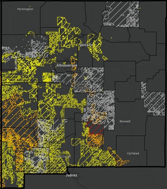
New Mexico Fire Viewer
NMFWRI’s GIS Team has developed the New Mexico Fire Viewer, an interactive web map that provides access to real-time and historical wildfire data. The web map integrates satellite imagery and GIS layers, allowing users to search for active wildfires by name and view perimeter boundaries and hot spots. These updates, sourced from satellite infrared images, refresh every few hours. Originally launched to track the Hermit’s Peak and Calf Canyon Fires near Las Vegas, NM, the Fire Viewer now includes wildfire data statewide, covering current, recent, and historical fires. View the NM Fire Viewer at https://nmfireviewer.org/.
The Fire Viewer includes multiple GIS layers to enhance situational awareness:

Smoke forecasts
Land ownership data
Soil burn severity maps
Burn scars from past fires
Building footprints (houses, barns, and other structures, sourced from Microsoft)
Vegetation treatment data from NMFWRI
………………………………………………………………………………
NM Fire Info Southwest Area Fire Restrictions Map
NMFireInfo.com is an interagency effort in New Mexico, created to provide timely and accurate information about wildfires and fire restrictions across the state.
One of the key features of the site is an interactive map that helps residents, landowners, and visitors quickly identify current fire restrictions in effect throughout the Southwest region. By clicking on a specific area of interest, you can access direct links to the latest fire restriction orders, closures, and/or official news releases for that location. While the map is a valuable resource, it may not always capture the most recent updates for every jurisdiction. For the most accurate and up-to-date fire restriction information, it’s always a good idea to check with your local fire department, government agency, or (if you're traveling to visit public lands) the relevant local land management office.
………………………………………………………………………………
AirNow Fire and Smoke Map

The AirNow Fire and Smoke Map is a tool for monitoring fine particle pollution (PM2.5) from wildfires. It does not track all airborne toxins or pollutants. This tool focuses on PM2.5, tiny particles in smoke that can travel deep into the lungs, enter the bloodstream, and pose serious immediate and long-term health risks - even to people far from a fire’s origin. Exposure to PM2.5 is especially dangerous for individuals with asthma, heart or lung conditions, children, older adults, and those who work outdoors. The map uses the Air Quality Index (AQI), a simple, color-coded scale ranging from "Good" to "Hazardous", to help users quickly assess how safe the air is to breathe.
Available in both English and Spanish, the interactive map allows you to click on icons to view detailed, location-specific information. This includes the current AQI, historical air quality trends, and the presence of any nearby fires or visible smoke plumes. For each AQI category, the map also highlights the groups most at risk and offers practical recommendations to reduce smoke exposure, such as staying indoors, using air purifiers, or wearing N95 masks. Understanding AQI empowers communities to make safer, healthier choices during wildfire events.
………………………………………………………………………………
Watch Duty

Watch Duty is a free app available for both iPhone and Android that provides real-time alerts about nearby wildfires, prescribed fire activities, and suppression efforts. The app offers detailed information, including active and historical fire perimeters, red flag warnings, satellite hotspots, and more. Unlike crowdsourced platforms, Watch Duty is powered by a trusted network of active and retired firefighters, dispatchers, and first responders. These experts monitor radio scanners and collaborate 24/7 to deliver up-to-the-minute updates.
If a wildfire threatens life or property, Watch Duty sends immediate alerts directly to your device. Each incident is continuously monitored, and updated alerts are sent until the threat is removed or the fire is fully contained.
………………………………………………………………………………
Living With Fire Social Media Toolkit
The Living With Fire Social Media Toolkit is a ready-to-use resource designed to help users share important wildfire preparedness information across your social media platforms. It includes a range of prepared messages that you can post as-is or customize to fit your audience’s needs. Topics include evacuation planning, creating defensible space, home hardening, living with smoke, prescribed fire, post-fire recovery, and preparing for post-fire flooding. The toolkit also features downloadable graphics to complement each key message. All materials, including graphics and messages, are available in both English and Spanish to help you reach diverse communities effectively.
An example of one of their pre-drafted messages:
“Strong winds can move wildfire smoke from an area on fire to communities otherwise unaffected, greatly reducing air quality and extending the health risks of wildfire. Learn more about smoke and how it travels at www.iqair.com”
………………………………………………………………………………
NWCG Community Engagement Recommendations
In February of this year, the updated NWCG Wildland Urban Interface (WUI) Mitigation Field Guide was released, offering practical guidance for mitigation practitioners of all experience levels. The guide provides strategies and recommendations for effectively and efficiently reducing wildfire risk in communities vulnerable to wildfire damage or destruction.

Image courtesy of NWCG: Fire Prevention Education Team
A key feature of this guide is a dedicated section on community engagement and partnerships. Building meaningful connections with residents is essential to driving successful community-wide risk reduction efforts. The guide emphasizes that communication strategies can vary. Some are proactive and interactive, while others are more passive or informational. Understanding when and how to use each approach is critical to success. The guide offers actionable advice on:
Facilitating community meetings
Creating effective messaging
Conducting media interviews
Leveraging social media platforms
Tailoring communication to specific audiences
Additionally, it includes a set of talking points for discussing wildfire and mitigating wildfire risk. These can be adapted to reflect your community’s unique demographics, forest conditions, and available resources, helping to make mitigation conversations more relevant and impactful.
An example of talking points from “Fire as Part of the Landscape”

FACNM Leader Spotlight

Photo of FACNM Leader Gina Bonner as seen in the Taos News
Regina “Gina” Bonner is the Firewise Committee Chair for Taos Pines Ranch POA, which is in an unincorporated region of SW Colfax County near the Village of Angel Fire. Gina has been a FACNM Leader since the beginning of 2023 and has made numerous significant contributions to building wildfire resiliency within her community. Below highlights some of Gina’s experiences and takeaways since joining the FACNM Network:
Q: Describe a life experience that helped shape your dedication and/or passion for your current work in building fire adapted communities.
A: I’ve always enjoyed the outdoors and natural resources. I’ve hiked and backpacked all over the state, and have catalogued rocks, fossils, birds, trees and wildflowers in Taos Pines Ranch. I will say, though, that the 341,471-acre Hermits Peak / Calf Canyon wildfire south of us definitely motivated me to get more involved in regional wildfire protection over and above Taos Pines Ranch Firewise.
Q: When you think about your work in wildfire preparedness, what is your vision for your community?
A: Reducing the wildfire risk rating for not only Taos Pines Ranch but also surrounding communities through fuels reduction and defensible space projects. This is important because fires do not recognize county or community boundaries. All of The Enchanted Circle has a high wildfire risk rating and should be considered as a whole for landscape treatments, forest health and watershed protection.
Q: What are one or two projects, partnerships, or efforts you’re especially proud of?
A: Partnering with the Cimarron Watershed Alliance (CWA) to write USDA Community Wildfire Defense Grants (CWDG) for SW Colfax County. This was done first as Taos Pines Firewise and later as a CWA board member. Affected communities in the awarded fuels reduction contracts thus far are The Flying Horse Ranch, the unincorporated areas of Moreno Valley and Ute Park, and Angel Fire.
Since CWDG is predicated on having a current Community Wildfire Protection Plan (CWPP), I value partnering with the Forest Stewards Guild to get priority projects and action plans into the Colfax County CWPP.
Q: What challenges or barriers have you faced in your work, and how have you worked through them?
A: Many property owners in Taos Pines are part-time and don’t have a good appreciation of the wildfire dangers because of the precipitation and humidity levels in their other environment. The idea of cutting down any tree, much less for defensible space, was of great concern because they wanted to live in a forest up here and not in the city. The resistance was slowly overcome over time through annual education, having annual chipper days, illustrating fire patterns overlain over Taos Pines lot lines with homes using fire SimTable exercises; plus the preponderance of wildfires near us. We are heading into our third thinning initiative and, once complete, 85% of the 1,200 Taos Pines lots will have been thinned at least once, and some twice.
Q: How has being a part of the FACNM Network supported or shaped your work?
A: FACNM supports Firewise by offering microgrants that can be applied to chipper day and education events. It’s always nice to meet and exchange ideas and lessons learned from other leaders across the network. FACNM website offers a wealth of resources and research on emerging topics like Insurance Institute for Home & Business Safety (IBHS) standards for wildfire prepared homes that are coming to New Mexico.
Q: What advice would you give to someone stepping into a similar role or just beginning this work?
A: Take advantage of the FACNM resources for meetings, workshops and materials. Reach out to them or other peers to explore grant opportunities and to get helpful tools. There is a lot to learn but a lot of resources to help because “you don’t know what you don’t know”.
Resources and Opportunities
Classes and Workshops
IFTDSS Course for Prescribed Fire Plans - online course, Enroll Now

Learn to use IFTDSS, available anytime on the Wildland Fire Learning Portal, for Burn Plans:
Use spatial modeling and include visuals in your plan
Element 4: Describe your Burn Unit with IFTDSS reports and fuel model data from LANDFIRE
Element 7: Build your prescription by using IFTDSS Compare Weather/Fire Behavior
Element 16: Find your critical holding points by running Landscape Fire Behavior
Element 17: Game out spot fires and escape scenarios with Minimum Travel Time (MTT) for your Continengency Plan.
Community Wildfire Protection Plans 2.0 Webinar Series - presented FAC Net and the Watershed Research and Training Center

Session 2: Integrating Smoke Preparedness into CWPPs
Wednesday, June 18 - 11AM to 12:30PM (MT)
Are you planning for smoke preparedness and mitigation in your community and looking to embed that work into your Community Wildfire Protection Plan? Join our discussion and talk with experts about tips and resources for integrating smoke considerations into your CWPPs
Fire-forward media
Weathered: Inside the LA Firestorm (T.V. Episode)
"Weathered" is a PBS series hosted by Maiya May that focuses on natural disasters and extreme weather events. The series explores the impacts of climate change and how communities can prepare for and respond to these challenges. In this episode, the host investigates what caused the 2025 LA Wildfires and how we can prevent future disasters.
