Wildfire Wednesdays #118: Southwest Fire Climate Adaptation Menu

Happy Wednesday, FACNM readers!

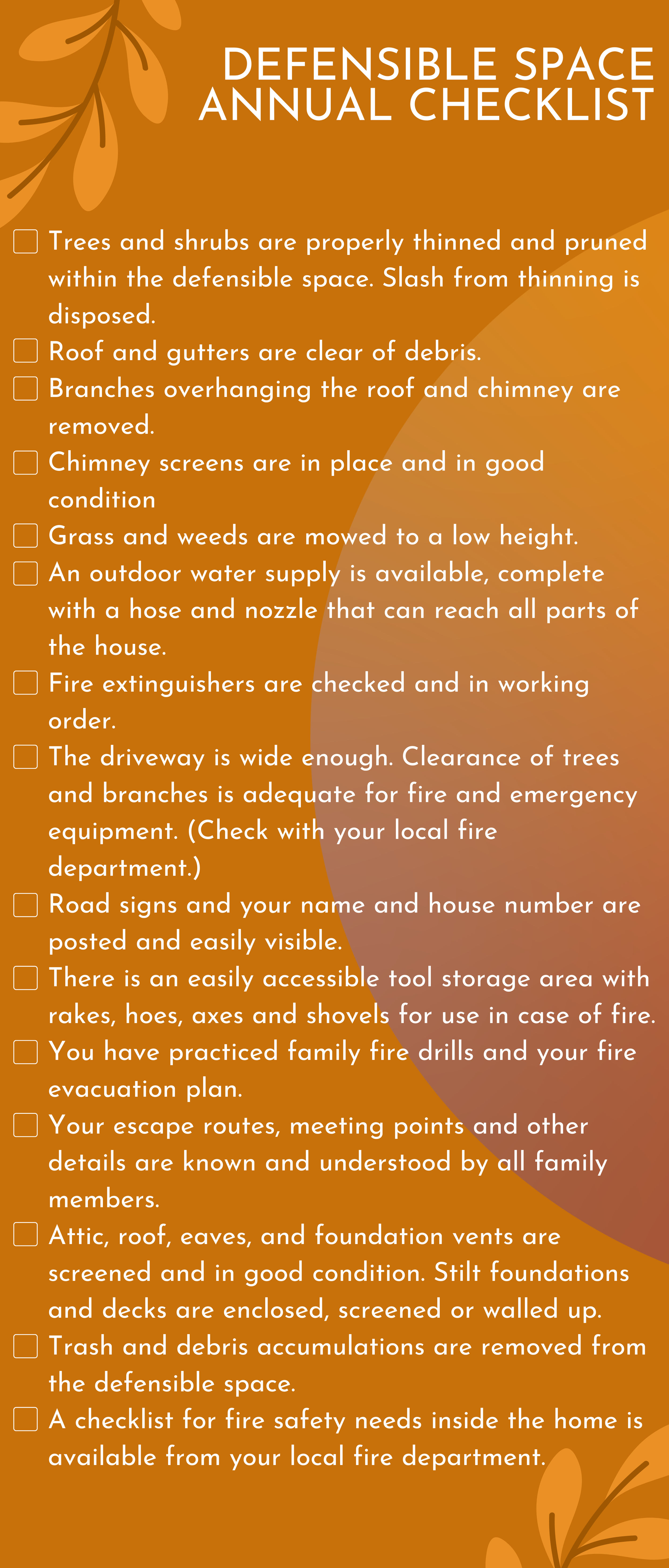
There are many organizations, entities, and companies who offer tools, templates, and guidelines to prepare for wildfire. We regularly cover these resources here in the blog, including a Fire Preparedness Day ‘Menu’ from the National Fire Protection Association, information about the Home Ignition Zone and Defensible Space, a video series called Seven Saturdays to a More Fire Resistant Home, and many more.

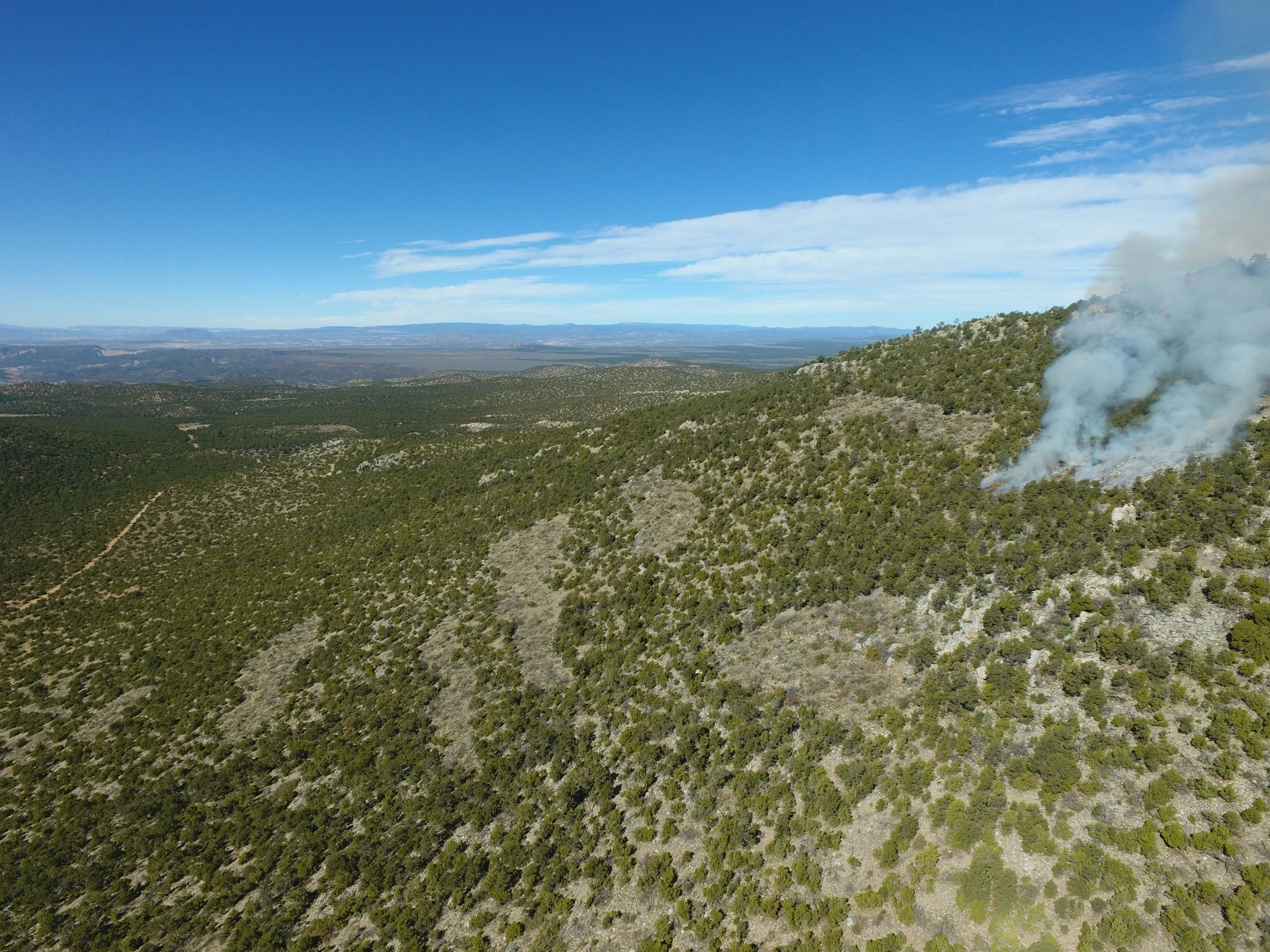
One aspect of these tools that is sometimes overlooked or under-investigated is climate change. This phenomena does and will continue to impact the likelihood, behavior, location, and severity of future wildfires, especially in the Southwest. Today’s Wildfire Wednesday addresses the parallels between climate readiness and Fire Adapted Communities as we dig into the Southwest Fire Menu, a product from Southwest FireCLIME: Research and Resources for Managing Fire in a Changing Climate.

Today’s Wildfire Wednesday features information on:

  • The Southwest Fire Menu basics

  • Useful tips and tricks to get started

  • How to get involved in the climate & fire conversation

  • Other resources and upcoming opportunities

Be well and stay fire safe as you enjoy the final month of summer!
Rachel


The Basics

An introduction to the Southwest Fire Menu

“Forests across the United States are expected to undergo numerous changes in response to the changing climate” write the authors of the second edition of Forest Adaptation Resources: climate change tools and approaches for land managers (2016). This paper, upon which the Southwest Fire Menu is based, “provides a collection of resources designed to help forest managers incorporate climate change considerations into management and devise adaptation tactics.”

From Forest Adaptation Resources: climate change tools and approaches for land managers, 2nd edition (2016) by Swanston, et al.

While the source publication details all five steps in the Climate Change Response Framework, including Define, Assess, Evaluate, and Monitor, the SW Fire Menu homes in on Identify: adaptation strategies and approaches for managing fire under future climate conditions. It is a product of Southwest FireCLIME, a regional initiative that applies the principles of science–management partnership and the co-production of knowledge to identify information needs related to climate-fire-ecosystem dynamics within the management community. Under the umbrella of Adaptation Strategies and Approaches, the Menu offers 10 ways that natural resources professionals can approach land management under an uncertain climate future.

The 10 strategies

Image courtesy of Lumen Learning: The Diversity of Life

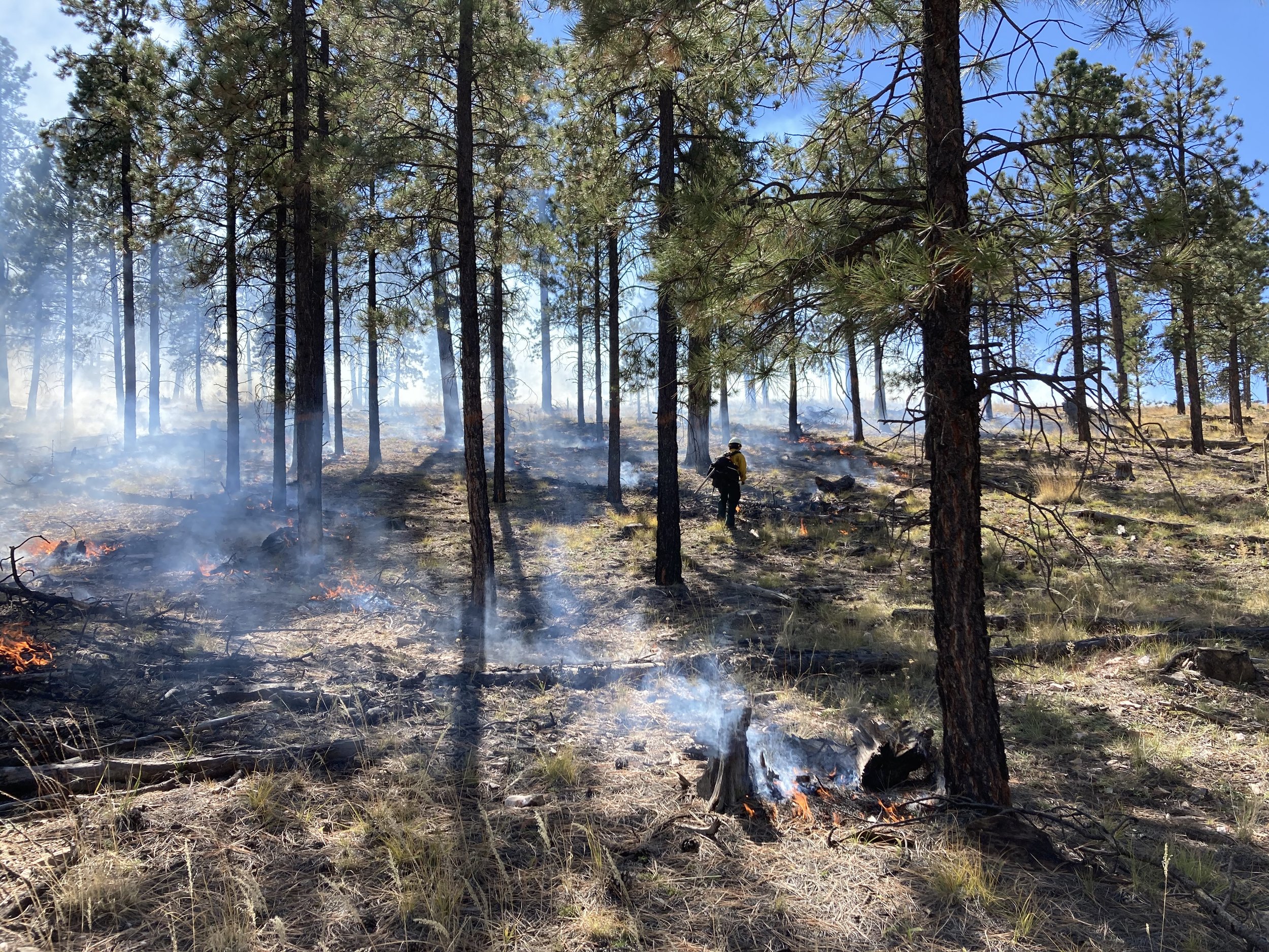
  1. Sustain fire as a fundamental ecological process
    Returning fire to landscapes and cultures where it has been artificially excluded has been shown to have a variety of ecological and social benefits, including the reduction in future wildfire activity that is more likely to occur at undesired spatial scale or severity.

  2. Reduce biotic and abiotic stressors affecting fire regimes
    When biotic or abiotic stressors alter fuel regimes and fire risk, fire regimes can undergo drastic changes over short periods of time.

  3. Reduce the risk of unacceptable fire
    Unacceptable fires may be ecologically uncharacteristic, socially undesirable, or both. Generally, management actions taken to reduce the risk of unacceptable fire will be preventative as opposed to reactive.

  4. Limit the effects of unacceptable fire and promote post-fire recovery
    Fire regimes altered by climate change are more likely to result in fires that are considered unacceptable. Thus, preventative treatment (pre-fire) and active restoration (post-fire) are important considerations necessary for mitigating ecosystem effects and enhancing recovery.

  5. Maintain and enhance structural, community, and species diversity using fire and fuels treatments
    Promoting higher structural, community, and species diversity from the stand to landscape scale will increase the likelihood that some subset of species and vegetation communities will persist in the future.

  6. Identify, promote, and conserve fire- and climate change-adapted species and genotypes
    Conserving and promoting climate- and fire-resilient species and genotypes that are already present may allow a similar vegetation community to persist further into the future.

  7. Facilitate ecosystem adaptation to expected future climate and fire regimes
    Promoting species adapted to future conditions increases the likelihood that forests and other fire-adapted ecosystems will persist through or recover from increased fire disturbances and novel fire regimes, reducing the likelihood of undesirable vegetation type conversion.

  8. Use fire events as opportunities for ecosystem realignment
    The immediate aftermath of a disturbance provides a very practical window for realigning successional trajectories to expected future conditions instead of historical references.

  9. Promote organizational and operational flexibility
    Management organizations that are able to respond adaptively and creatively to changing fire regimes may be able to increase efficiency and successful outcomes of management actions.

  10. Promote fire-adapted human communities
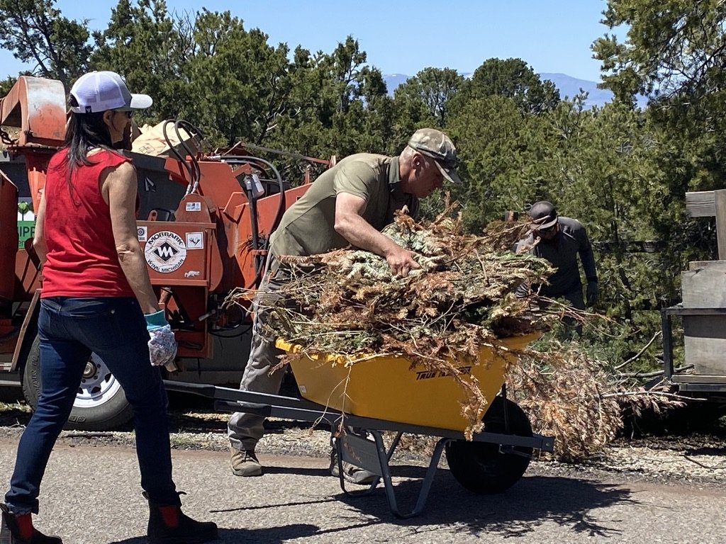
    Individuals and communities have essential responsibilities within a climate adaptation framework, both in modifications to the physical environment and our collective understanding of challenges and solutions.

All 10 strategies are organized within a decision-making system commonly applied to management of post-fire landscapes called the R-A-D framework (Resist-Accept-Direct). Within the Menu, each strategy fits under one or more of these three concepts: Resistance, Resilience, and Transition.


Using the Menu

Tips and tricks to get started

The Menu is intended to be used as part of the Adaptation Workbook process developed by the Northern Institute of Applied Climate Science (NIACS) and available online through the Climate Change Response Framework (CCRF). The Adaptation Workbook provides a structured yet flexible approach for integrating climate change into conservation and management projects. CCRF offers an implementation guide for both natural resources professionals and land trusts. These guides offer a short description and example for each step of the adaptation process, as described above. They are intended to be utilized in the beginning planning stages of a natural resources project, but are good to refer to at any point. A four-page set of worksheets at the end of the guide can be used to do a quick and easy exploration of adaptation for a small project area.

Tactics for implementation and examples of each of the 10 strategies outlined in the Fire Menu can be found on FireCLIME’s website as a dropdown for each individual strategy; additional examples and suggestions can be found in the parent paper’s Appendix A. Fire Menu with Example Tactics.


Get Involved in Climate and Fire Planning

Next steps to learn more

Housed under the Southwest Climate Adaptation Science Center at University of Arizona, the Southwest Fire and Climate Adaptation Partnership (SWFireCAP) is an open and inclusive group of partners with a shared vision for working together to advance fire and climate adaptation in the southwestern US. Their work is founded in the belief that the monumental task of effective climate adaptation requires cross-organization collaboration and leveraging of people, time, resources, and funding. Initiated by the Southwest Climate Adaptation Science Center and the Southwest Fire Science Consortium, the SWFireCAP now has several partner organizations and is open to anyone interested in the intersection of climate change and fire in the Southwest. The group offers research briefs, project summaries and publication, roundtables for targeted discussion (on-the-ground adaptation and cultural burning), workforce development fellowships, and more.

The SWFireCAP’s vision is “working together to advance fire and climate adaptation in the Southwest.” They are guided by the principles of inclusivity, cultural awareness, collaboration, evidence informed, consensus based, transparency, and collective impact.


Other Resources

Webinars

Wednesday, 13 September at 12:00pm MDT: Grassification and Fast-Evolving Fire Connectivity and Risk in the Sonoran Desert
In the second webinar of a series on invasive grass-driven changes in dry desert systems, presenters will discuss their findings on fire dynamics in the 2020 Sonoran Desert Bighorn Fire near Tucson, AZ to better understand the changing nature of fire in desert systems which are increasingly experiencing conversion to grasslands.

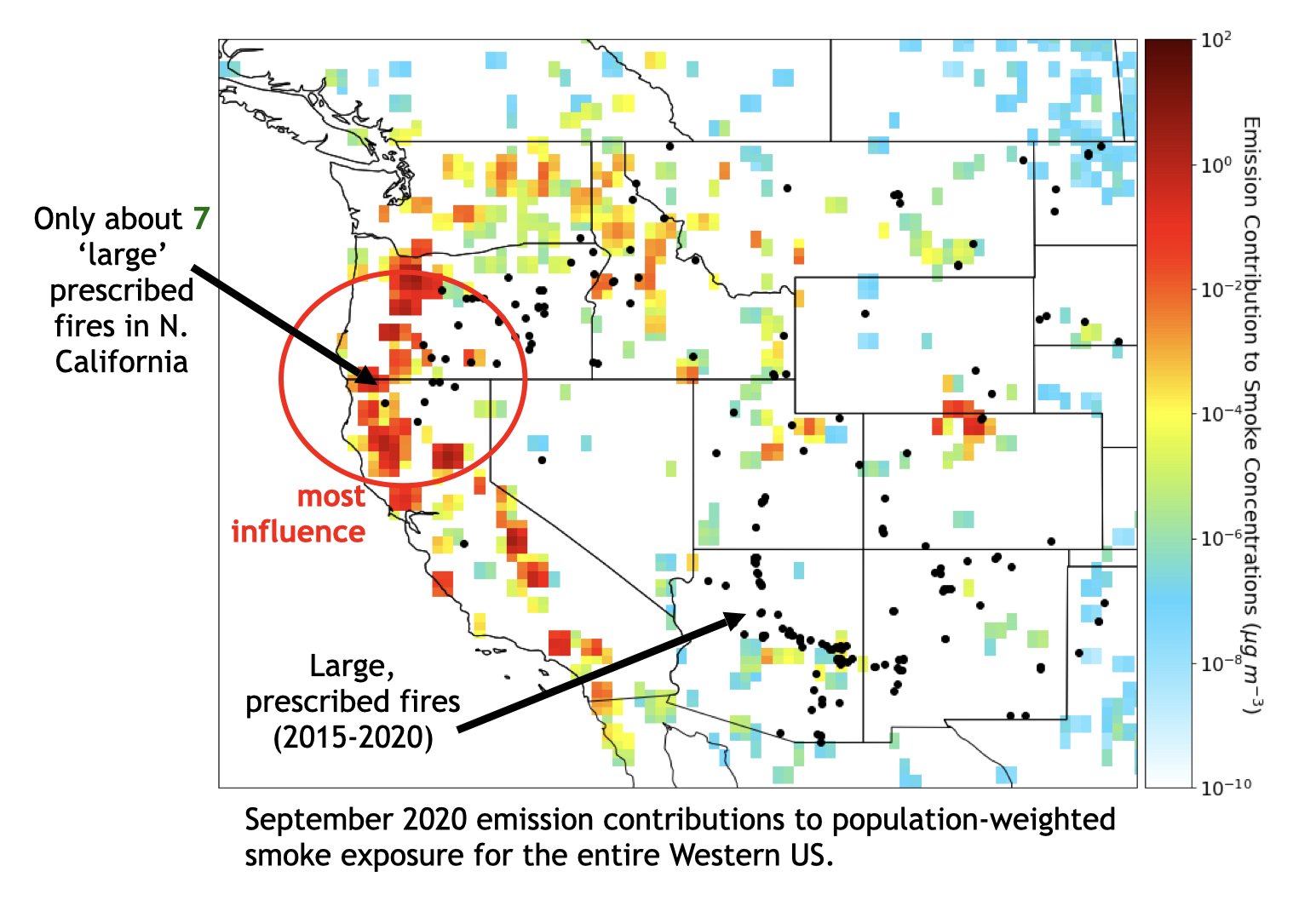
Wednesday, 11 October at 12:00pm MDT: Prescribed Burns as a Tool to Mitigate Future Wildfire Smoke Exposure
Tune in for a webinar co-hosted by FACNM and the SW Fire Science Consortium! This presentation will introduce research on how targeted prescribed burn treatments in heavily forested Western states may have an outsized impact on improving air quality forecasts for the entire western U.S. by reducing the likelihood of future wildfire smoke.

Local conferences

November 6-10, 2023: 6th National Cohesive Wildland Fire Management Strategy Workshop
Read more and register now for this national gathering of fire management professionals working in in local, state, Tribal and federal agencies and organizations as well as non-governmental organizations and private companies! Hosted by the National Fire Leadership Council, the workshop will focus on peer-to-peer learning centered around a shared framework for the future.

Recent research

Home hazard assessments: the Science You Can Use bulletin titled “Sometimes Simple Works: The Value of Rapid Parcel-Level Wildfire Risk Assessments” focuses on how the rapid property assessments conducted by a Wildfire Research (WiRē) team for a Colorado neighborhood held up when the East Troublesome Fire burned through the area. WiRē has conducted assessments and public opinion surveys in the greater Santa Fe area, the results of which are expected to be released later this year.

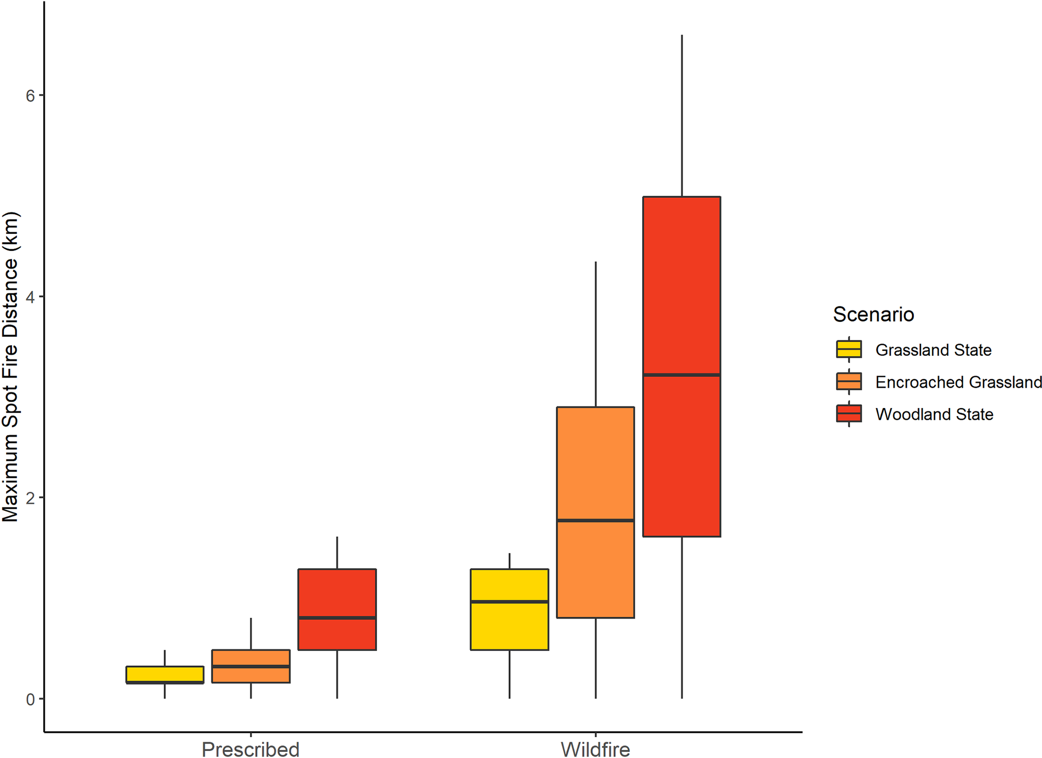
Fire behavior in wildland versus prescribed fires: “Spot-Fire Distance Increases Disproportionately for Wildfires Compared to Prescribed Fires…” is based on work in the Loess Canyons Experimental Landscape in Nebraska. This research investigates how forest encroachment into grasslands drastically increases risks associated with wildfire, and how spot fire (embers from one fire causing a new fire ignition) distances associated with woody encroachment are much lower in prescribed fires used to control woody encroachment compared to wildfires.

Movie night

Rocky Mountain PBS aired the half-hour documentary “CO-Existing With Wildfire” in July 2023. It is now available to stream.  

Wildfire Wednesdays #117: Community Wildfire Defense Grant Program

Happy Wednesday, FACNM folks.

The Southwest’s delicate ecological balance is increasingly disrupted by the devastating force of high severity wildfires, wreaking havoc on landscapes, homes, and lives. In recent years, the frequency, intensity, and impact of wildfires have grown, highlighting the urgent need to implement effective mitigation strategies. The Community Wildfire Defense Grant (CWDG) Program was introduced in 2022 as a tool to assist communities across the US grappling with a growing threat. This innovative initiative is about more than funding; it represents a united desire, from Washington D.C. to our own backdoors, to create and bolster resilience against the fires that threaten our homes and environment. In this week’s Wildfire Wednesday, we delve into the basics of the Community Wildfire Defense Grant Program, exploring its significance, objectives, and the transformative impact it aims to have on wildfire management.

Today’s Wildfire Wednesday features:

  • An introduction to CWDG

  • Round 1 awards and insights

  • Application tools & data

  • Round 2 announcement

  • Upcoming opportunities

-Alyssa


What is the Community Wildfire Defense Grant Program?

An overview

The Community Wildfire Defense Grant (CWDG) Program is a comprehensive approach to building community, ecological, and structural resilience and preparedness in the face of wildfires. Administered by the USDA Forest Service, this program stems from the recognition that safeguarding communities against wildfires requires a multifaceted strategy. It aims to empower local communities, organizations, and agencies to forge partnerships that foster cooperation and shared expertise in order to create and implement wildfire protection plans.

The primary objectives of CWDG are twofold: to enhance community preparedness and to mitigate wildfire risks. This is achieved through a range of focus areas that address different aspects of wildfire defense:

  1. Community Engagement: The program encourages active participation from residents, local authorities, and fire departments. By fostering a culture of collective responsibility, communities are better equipped to identify vulnerabilities and devise strategies for prevention, early detection, and evacuation.

  2. Fuels Reduction: One pivotal component of wildfire management is reducing the amount of flammable material that can serve as fuel for fires in both urban and rural areas. The grant program supports projects such as vegetation management, thinning, controlled burns, and creating defensible spaces around homes and critical infrastructure.

  3. Education and Outreach: Knowledge and a shared understanding of needs and objectives are the cornerstone of an effective wildfire defense. CWDG prioritizes educating communities about fire-safe practices, evacuation procedures, and the science of wildfires. Public awareness campaigns and workshops play a pivotal role in creating informed and prepared communities.

The CWDG initiative heralds a transformative shift in wildfire management. It nurtures collaboration among diverse stakeholders, blending traditional wisdom with current technological and scientific advancements. By focusing on both immediate action and long-term resilience, the program fosters a sense of ownership, ensuring that communities are not just recipients of assistance, but active participants in their own safety. 


Round 1: Autumn 2022

Awards and Insights

In a significant stride towards bolstering community wildfire resilience, the Community Wildfire Defense Grant Program's inaugural funding round has yielded promising outcomes. A total of 100 projects have been approved for funding, with an impressive allocation of $197 million dedicated to these initiatives. The program's wide reach is evident, as it spans across 22 states and extends support to 7 tribes, fostering a collaborative approach to wildfire mitigation. Notably, within this diverse landscape of projects, New Mexico stood out with five applicants successfully securing funding. These projects include:

  1. Colfax Collaborative Wildland Urban Interface Project ($8.8 million)

  2. Flying Horse Ranch Fuel Break Project ($1.8 million)

  3. Exercise and Project Implementation of Community Wildfire Protection Plan ($235k)

  4. Sandoval CWPP Update ($63k)

  5. Community Wildfire Mitigation in the Greater Santa Fe Fireshed ($1.3 million)


Application tools & data

Assistance evaluating risk for Round 2 applicants

"Wildfire Risk to Communities" is a user-friendly website developed by the USDA Forest Service to aid communities in comprehending and decreasing their vulnerability to wildfires. This platform, established at the directive of Congress, offers interactive maps, charts, and resources to support informed decision-making. Utilizing the most up-to-date research insights, the website identifies and assesses wildfire vulnerability, equipping communities with the necessary tools to manage and mitigate these risks. The data used in the project is drawn from consistent sources like LANDFIRE for vegetation and fuels, the National Weather Service for weather information, and the U.S. Census Bureau for community data. Notably, wildfires and significant disturbances that happened after 2014 are not yet included in the data.

The website is primarily designed for community leaders such as elected officials, planners, and fire managers. It provides a broad perspective on risk across regions, states, and counties. While accessible for exploration online, the data can also be downloaded as GIS raster layers which enables more in-depth and personalized analysis. The website is intended to be used to compare risk among communities rather than within them and is not suitable for evaluating risk at the local, neighborhood, or individual home level.

An important feature is the CWDG tool, which allows users to specify a specific region or community and generate eligibility criteria data for their CWDG application. Applicants can cut and paste the risk information directly from the Wildfire Risk to Communities site into their application, increasing their likelihood to be selected for Round 2 funding by increasing their alignment with the application terms.

Workshop tips for applicants - recording available

In July 2023, FACNM and the New Mexico EMNRD Forestry Division held a series of workshops to assist potential Round 2 applicants with their proposals. Topics included:

  • Lessons Learned from Round 1

  • CWDG Process Updates

  • EMNRD Forestry Division Compliance, Procedures and Resources

  • Cycle 2 Application Review

A recording of one such workshop, held in Santa Fe, is available for viewing on the FACNM Facebook page.


Round 2: Summer 2023

Request for Proposals now open

The second round of CWDG Program funding is open for applications until October 31, 2023!

Eligible entities include local governments in wildfire-prone areas, Tribes, non-profit organizations, state forestry agencies, and Alaska Native Corporations. There are two proposal categories: 1) Community Wildfire Protection Plan (CWPP) Development/Revision, and 2) CWPP project implementation. Priority will be given to applications representing high-risk areas, low-income communities, and those impacted by recent disasters. Funding limits range from $250,000 to $10 million per project, with potential for up to $250 million in total funding. Funds matching is required, with waivers available for specific cases.

UPDATE: View FAC Net’s August 14 blog to learn more about Round 2, tips and tricks for your proposal, and how to apply!


Upcoming Opportunities

Webinars

  • 10 August at 12pm MDT: Monitoring and Removal of Invasive Grasses for Restoration of Dry Desert Systems.
    In this webinar, a panel of scientists and practitioners will discuss a number of management techniques and research questions being utilized or tested in an effort to reduce the presence of introduced grasses and restore the historic fire regime in dry desert systems such as the Sonoran. This information can be used to improve current practices and help develop new approaches to slow the invasive grass-fire cycle in the southwestern US.

Conferences

Wildfire Wednesdays #116: Seed Funding for Community Fire Preparedness

Happy Wednesday, FACNM readers!

Whether you’re a FACNM Leader, a seasoned FireWise community member, or are just learning about what it means to be fire adapted, figuring out where to start on the journey to community wildfire preparedness can feel pretty daunting. From the risk assessments to community organization to funding, there are a lot of details to work out.

In spring of 2023, FACNM began offering seed funding to FACNM Leaders and Members through a novel Microgrant Program. Individuals or Organizations could apply for up to $2,000 to buoy their community fire preparedness efforts - convening educational gatherings, enabling on-the-ground risk mitigation work, developing grant proposals to secure long-term funding, and more. In total, five applicants were chosen as award recipients and carried out a wide range of events, all of which aid in the development of Fire Adapted Communities.

Applications for a second round of funding for the FACNM Microgrant Program will be opening soon! To apply, ensure you are a registered FACNM Leader (click here to learn more) and visit the Microgrant webpage in mid-August to fill out the application form.

Today’s Wildfire Wednesday features:

  • Reports from the field: FACNM Microgrant success stories

  • Upcoming opportunities

Be well and stay cool,
Rachel


Reports from the Field: FACNM Microgrant Success Stories

Hazardous fuels removal - hauling and chipping:
The Overlook Homes Association and La Barbaria Canyon

In May, nineteen residents from The Overlook Homes Association and La Barbaria Canyon participated in their first annual National Wildfire Community Preparedness Day. The event was jointly coordinated by Greater Santa Fe Fireshed Coalition Ambassadors Ute Haker, Chris Schaum and Pam Ryan. Leading up to the Preparedness Day, community leaders engaged in educational outreach to other community members which focused on the concept of creating defensible space through vegetation removal, thinning, and home hardening.

The HOA received financial support from FACNM in the form of a Microgrant, as well as logistical support from Chris' Tree Service and the Forest Stewards Guild. Additional funding from Coalitions and Collaborative (COCO) AIM made it possible to offer residents, at no cost to them, both green slash disposal in a dumpster which was set on-site and slash chipping and hauling. The majority of material collected consisted of bagged needles, leaves and pinecones as well as ponderosa, pinion and juniper branches.

Participation between the two communities was evenly divided with a total of 4.25 tons of green waste collected over a period of 6 hours. All of the participants joined hands across the canyon in the true spirit of community to make this National Wildfire Preparedness Day a resounding success!   

Education and information exchange through in-person learning:
Wildfire Research Center (WiRē) and City of Santa Fe Fire

The City of Santa Fe Fire Department partnered with the Wildfire Research (WiRē) Center – a non-profit that works with wildfire practitioners across the western United States – to develop locally-tailored, evidence-based community wildfire education efforts so that communities can live with wildfire. Together, they conducted two data collection efforts: a rapid wildfire risk assessment of 965 residential properties, and a household survey sent to the owners of those same properties. The findings from this study are helping the City of Santa Fe Fire Department professionals better understand local wildfire risk and actions needed. These findings can also help residents know more about their property's risk and what actions they can take to reduce their risk.

WiRē Center was the recipient of a Fire Adapted Communities New Mexico (FACNM) Microgrant, which provided funding for space in which to hold in-person meetings with the Greater Santa Fe Fireshed Coalition and members of the Fireshed Ambassadors Program. In-person meetings enable more meaningful conversations among our collaborators, which leads to deeper understanding of the results of our project and how the data can be leveraged to inform programmatic improvements and more effective use of local resources. In the meetings supported by FACNM, WiRē presented on the results of our data collection efforts in Santa Fe to the Fireshed Coalition and its Fireshed Ambassadors tasked with public engagement, providing actionable information about wildfire mitigation.

These meetings were a catalyst for potential future projects. As a direct result of meeting with the Fireshed Coalition, they are considering a path toward a Fireshed-wide WiRē project. Some Fireshed Ambassadors expressed surprise at WiRē’s survey results and stated that those would inform how they interact with neighbors in the future. FACNM’s Microgrant support enabled the City to build momentum and generate ideas for how these data can be used to support wildfire adaptation in Santa Fe.

WUI fuels reduction demonstrations:
High Desert HOA - Fire Preparedness Committee

The Fire Preparedness (FP) Committee of the High Desert Residential Owners Association (HDROA) in Albuquerque, NM sponsored an education event through a unique and family-friendly hazardous fuel thinning demonstration in a communal arroyo comparing “goatscaping” with manual vegetation removal by landscapers. The goal of the project was to show how appropriate fuel reduction can be done to alter the path of a wildfire in a dense arroyo to protect homes. In 2018, the community experienced a 7-acre arroyo wildfire that engulfed everything in its path stopping only at residential property walls. Ten homes were damaged. The question was when, not if, we have another fire, how can the fire be directed to meet its combustion needs by protecting defensible spaces around homes and creating combustion sources away from homes.

High Desert received a Microgrant from FACNM with three goals in mind:
1. Secure approval from the City of Albuquerque to thin understory fuels in a 3-acre portion of the City Park.
2. Arrange an 8-hour period of goat and sheep grazing in a portion of the 3-acres, followed by 8 hours of manual fuel removal on another day for comparison.
3. Organize and publicize an educational event in the City’s Park with fire personnel and related environmental agencies for the High Desert residents that would allow direct interaction of the public with the animals and members of the FP Committee to explain the demonstration.

Approximately, two dozen community members attended the educational event. Officers of the HOA, ABQ Fire Rescue (AFR) Wildland Fire, FACNM, and ABQ Water Authority manned information tables and were on-site to answer questions. Lessons learned for both community members who attended the event and FP Committee Members included:

  • Goats do a great job of reducing fire risk where there are fine fuels like grasses, but do not change the fire behavior potential in arroyos dominated by shrubs and woody plants.

  • The paramount focus for fire preparedness of homes near arroyos needs to be fire hardening of the home within 0-6 feet of the exterior - in the Defensible Zone.

  • The secondary effort needs to be on reducing fuel in the Intermediate zone (6-30 feet) between a structure and the arroyo.

  • Into the Extended zone, 30-100 feet into the arroyos, reducing the available fuel and creating natural fuel breaks will change the fire behavior by slowing the movement of the fire and its intensity, thus also reducing embers.

Learn more about creating defensible space around your home in Wildfire Wednesdays #109 and #109B.

CWPP updates:
Cimarron Watershed Alliance, Inc.

The Cimarron Watershed Alliance, Inc. (CWA) is a collaborative watershed stakeholder nonprofit based in Colfax County, NM. CWA’s mission is “to strive for and maintain a healthy watershed for all residents through collaborative community activities involving all stakeholders with an interest in water”. 

In line with their mission, CWA led the effort to develop the first Colfax County Community Wildfire Protection Plan (CWPP) in 2008 as well as the subsequent Update in 2022. In late 2022, members of CWA identified gaps in, and a subsequent need for updates to, the 2022 Colfax County CWPP, particularly in regard to pre-identifying fuels reduction projects.

In early 2023, CWA received a FACNM Microgrant to support this 2023 CWPP update effort in the form of two Colfax CWPP meetings in Cimarron and Eagle Nest.  The Microgrant provided food for the meetings as well as technical advisory support from the Forest Stewards Guild for the updates themselves.

Representatives from the County, state and federal agencies, local landowners and managers, municipalities, and NGOs were in attendance at both meetings. Attendees were able to share and discuss their high priority projects and projects that are on the properties they manage or that directly affect them.  They were also able to collaboratively discuss projects that were a high priority within the county, those that affected everyone. In the end, CWA was able to come away with a larger list of wildfire protection priorities and projects within the County.  

Defensible Space Slash Disposal and Community Chipper Day:
Taos Pines Ranch

Cut green waste was hauled by residents to the side of the road prior to the chipper day to be processed by Wood Sharks, LLC.

Taos Pines Ranch is a 1,200-acre high elevation Firewise subdivision with 98 lots in Northern New Mexico that shares borders with Carson National Forest, Taos Pueblo, and some private land. In years prior, Colfax County provided an industrial chipper and a crew to chip resident-produced slash which is hauled to the edge of their 9 miles of road. The County discontinued this free service in 2023 due to lack of staffing. Residents, motivated to create defensible space around their homes following 2022’s devastating wildfires, had to look into other options.

Chipped green waste along the road leading through Taos Pines Ranch after a free-to-the-community slash hauling and chipper day.

Taos Pines requested and received a $2,000 microgrant from FACNM to contract an identical service from Wood Sharks, LLC. The community’s Firewise Committee alerted residents by sending chipper dates in a group email and posting on their Facebook Message Board.

All together, the community hauled out estimated 1,200 cubic ft. of slash produced by defensible space thinning. 70% of Taos Pines Ranch lots are fully or partially thinned, although the community hopes to bolster this number. In the future, over 1/5th of lot owners have expressed interest in working with the Cimmaron Watershed Alliance to create defensible space as part of that group’s USFS Community Wildfire Defense Grant (CWDG) award.


Upcoming Opportunities

Webinars

  • 10 August at 12pm MDT: Monitoring and Removal of Invasive Grasses for Restoration of Dry Desert Systems.
    In this webinar, a panel of scientists and practitioners will discuss a number of management techniques and research questions being utilized or tested in an effort to reduce the presence of introduced grasses and restore the historic fire regime in dry desert systems such as the Sonoran. This information can be used to improve current practices and help develop new approaches to slow the invasive grass-fire cycle in the southwestern US.

Conferences

  • 15-17 April 2024: After The Flames in-person conference and workshop
    A first-of-its-kind Conference and Workshop devoted to post-fire recovery. Attendees will represent individuals, organizations, and agencies impacted by wildfire and responding to the post-fire impacts, as well as experts in the arena of post-fire recovery. Sign up for Coalitions & Collaboratives’ newsletter to stay up-to-date on conference details. 

Learning Exchange: Field Tours

  • 26-28 September 2023: Stewardship in Action - A Tribe’s Nature-based Approach to Watershed Restoration
    The Natural Areas Association (NAA) is hosting a Stewardship in Action Field Workshop in Espanola, New Mexico on the lands of the Santa Clara Pueblo. It will highlight an innovative and iconic case study in public and private collaboration on sovereign tribal lands following a series of catastrophic wildfires. Learn more by visiting FACNM’s Events page.

Local Job Opportunities

  • Luna Community College: Director of Wildfire Resiliency Training Center
    Wildfires are growing worse every year - both bigger and more frequent. To combat the devastation, we need more people with the skills and expertise to mitigate the dangers and implement recovery for lands, forests, water and communities. Luna Community College is opening a Wildfire Resiliency Training Center. Apply for the Wildfire Resiliency Training Center Director position by contacting Dr. Day at 505-454-5378 to discuss the Center and the position in greater detail.

Wildfire Wednesdays #115: Sources of up-to-date wildfire information

Howdy, FAC NM Folks:

The crackling of dry leaves underfoot echoes through the forest, accompanied by the distant rumble of thunder. The smell of smoke wafts on the breeze, a stark reminder of the potential danger lurking just beyond the trees…

In the face of wildfires, staying informed could mean the difference between escape and chaos. In this week’s Wildfire Wednesday, our newest blog contributor, Alyssa, will showcase how to stay up to date with the ever-changing wildfire landscape. From technology-driven solutions to the power of community engagement, we delve into the strategies and resources available to ensure that, in the face of uncertainty, we remain connected, informed, and prepared.

Today’s Wildfire Wednesday features:

  •  Emergency Alerts

  • NMFireInfo

  • InciWeb

  • Fire Restrictions map


Emergency Alerts

Text & email emergency alerts are common across the US. One example, in Santa Fe, is the Alert Santa Fe notification system: this is a comprehensive communication system implemented in the city of Santa Fe, designed to quickly and effectively deliver important information to residents and visitors. It aims to enhance public safety and provide critical updates during emergencies, severe weather conditions, and other significant events. The system utilizes various communication channels to reach a wide audience, including mobile devices, landlines, email, social media platforms, and outdoor warning sirens.

The Alert Santa Fe system allows users to register their contact information, preferences, and geographic locations to receive tailored notifications based on their specific needs and interests. This customization ensures that individuals only receive relevant alerts pertaining to their area of interest or potential hazards. The system can issue alerts related to emergencies such as wildfires, floods, hazardous material incidents, and public health emergencies. It can also provide information about traffic disruptions, utility outages, and community events.

Through the mobile application or web portal, users can receive real-time alerts, view interactive maps with incident locations, and access additional resources and instructions during emergencies. The system leverages the latest technology to deliver notifications rapidly, ensuring that residents stay informed and can take appropriate actions to protect themselves and their loved ones.

Contact your local fire department for more information on local and county alert systems in your area.


NMFireInfo

The NMFireInfo website is a dedicated online platform that provides information about wildfires and other fire-related incidents in the state of New Mexico. It serves as a central hub for sharing up-to-date information, news updates, and resources related to fire incidents and fire management efforts.

Managed by various agencies and organizations involved in fire management, including federal, state, and local entities, the NMFireInfo website offers a comprehensive overview of fire incidents occurring within New Mexico. The website provides detailed information on the location of fires, fire size, containment status, and any evacuation notices or road closures in effect.

In addition to incident-specific updates, the website offers resources and educational materials to help residents and visitors understand fire prevention, preparedness, and safety. It provides guidelines on creating defensible space, fire restrictions, and other measures to mitigate the risk of wildfires.

The NMFireInfo website serves as an essential communication tool, allowing incident management teams to share information with the public, media outlets, and other stakeholders. By providing timely and accurate information, the website helps promote public safety and awareness during fire incidents.


InciWeb

InciWeb is an online incident information system that provides comprehensive and up-to-date information about wildfires, prescribed burns, and other incidents in the United States. It serves as a centralized platform for sharing incident-related data, including fire status, containment efforts, evacuation notices, and resource management.

Managed by the U.S. Forest Service, InciWeb offers a user-friendly interface where incident management teams, government agencies, and the public can access detailed information about ongoing incidents. The platform features incident-specific pages that contain maps, news updates, photos, videos, and other resources related to the incident.

InciWeb plays a vital role in facilitating communication and coordination among various agencies involved in incident response, including federal, state, tribal, and local organizations. It serves as a valuable tool for incident commanders to share situational awareness with stakeholders, media outlets, and the public, ensuring transparency and promoting safety.

By providing real-time information on fire behavior, containment strategies, road closures, and evacuations, InciWeb helps residents and visitors make informed decisions regarding their safety and well-being. It also serves as a repository of historical incident data, allowing researchers, analysts, and emergency management professionals to study and learn from past incidents.


Fire Restrictions map

The Southwest Area Fire Restrictions website is an online platform that provides information on fire restrictions and related regulations in the Southwest region of the United States. The website serves as a central resource for accessing up-to-date information about fire restrictions, closures, and other regulations implemented by federal, state, tribal, and local agencies.

Managed by fire management authorities in the Southwest Area, which includes states like Arizona, New Mexico, and portions of Texas and Oklahoma, the Fire Restrictions offers a user-friendly interface that allows visitors to access the latest information regarding fire restrictions in specific locations.

The website provides a comprehensive overview of current fire restrictions, including details about prohibited activities, such as campfires, outdoor burning, and the use of fireworks. It also highlights any specific regulations or closures in effect for national parks, forests, and other public lands.

Through interactive maps and search functionalities, users can navigate the website to find information relevant to their desired location. The dashboard includes additional resources, such as fire prevention tips, educational materials, and links to local fire management agencies for further guidance.

The Southwest Area Fire Restrictions website plays a crucial role in promoting fire safety and prevention by providing accurate and updated information to the public, recreational users, and land managers. It helps ensure compliance with fire restrictions, reduces the risk of human-caused wildfires, and supports the effective management of fire-prone areas in the Southwest.

Staying up to date on wildfire information empowers individuals and communities to take proactive measures, collaborate with authorities, and contribute to mitigating the devastating impacts of wildfires.


Upcoming Events and Learning Opportunities

Workshops

July 17 and 21, 2023: Community Wildfire Defense Grant Workshops

NM EMNRD - Forestry Division will hold two workshops to help potential CWDG grant applicants review the lessons learned from the first cycle of this program and learn about changes to current processes. This workshop is intended to help strengthen applications in real time, whether applications submitted in the first round did not get funded or individuals are still thinking about submitting an application. Participants should bring their latest revision of their application for review or their project ideas which have not yet been fleshed out into an application so Forestry Division can provide direction and helpful tips for success. 
If you are unable to attend either of the in-person meetings and would like to have your application reviewed, you can reach out to Abigail Plecki, Community Wildfire Defense Grant Coordinator, and set up a time to meet virtually (505-231-3086 | abigail.plecki@emnrd.nm.gov).   

To join online on the 17th, click here.

To join online on the 21st, click here.

Webinars

July 25, 2023, 12:00-1:00pm: Increasing Post-Wildfire Planted Seedling Survival
Join the Southwest Fire Science Consortium as Chris Marsh with UNM’s Earth Systems Ecology Lab discusses how consideration of climate trends, microclimatic conditions, topography, and local vegetation influence planted seedling survival and can be used to guide reforestation planning in the Southwest.

Resources in the News

Following the East Coast’s inundation of wildfire smoke from blazes burning in Canada, National Public Radio (NPR) published an article on lessons from the West for dealing with wildfire smoke. While this may be old news to many, the refresher is always worthwhile.
Read it here.

Wildfire Wednesdays #114: The Importance of Returning Fire to the Landscape

Happy Wednesday, and happy official start of summer, FAC NM community!

Our last Wildfire Wednesday issue, #113, introduced the idea of building landscape resilience (ability of the land to maintain ecological function after a disturbance) through large-scale collaborative land management projects. A common theme was that land managers use forestry treatments such as thinning and prescribed fire to support landscape resilience by creating a diversity of forest structures on the landscape. Local research has shown, time and again, that using targeted forest thinning followed by the intentional return of fire to treat an overly thick and unhealthy forest is the most effective combination for establishing landscape resilience in fire adapted ecosystems. Prescribed burning is a key element in guiding watersheds and forests to be more diverse in species, age, and spacing, and better prepared for wildfire, pests, disease, and other disturbances.

Today’s Wildfire Wednesday features:

  • A review of the use of intentional fire

  • Success stories in your backyard

  • Upcoming events and announcements

Take care,

Rachel


Use of Intentional Fire

A natural history

Many forests across North America but especially in the West “grew up” with fire. Over hundreds of thousands of years, as these landscapes formed, fire was present and endemic plants and animals evolved to be resilient to wildfire (or in some cases, to require it for their reproduction and survival). We refer to these ecotypes as fire adapted forests.

Cartoon drawing of a smiling tree hugging flames licking against its trunk

Communities of the Southwest have, in the past, been fire adapted as well. As we discussed in Wildfire Wednesdays #107, humans and our ancestors have been intentionally using fire for more than 400,000 years. Indigenous communities around the world have used fire in ceremony and management of hunting and plant cultivation, and Euro-American colonizer-settlers used fire to clear land around their communities. This use of fire, mimicking or working in tandem with naturally ignited wildfires, kept forests relatively thin and diverse with a mosaic of open meadows, thick groups of trees in drainages and other topographic features which acted as refugia, and less dense forest along slopes and ridgetops. Fire also maintained a diversity of tree ages and plants which grew under the forest canopy or along streams and rivers.

Smokey Bear poster with a fire blazing in the background, Smokey holding a hurt deer fawn, and the words " our most shameful waste" in bold black letters

After a century of treating forests as a commodity which needed to be protected from “bad” fire, including demonizing and sometimes criminalizing indigenous and other traditional use of fire, folks across the West have begun to reevaluate this relationship. While farmers and ranchers more or less continually used fire to maintain their land, even when fire suppression was the national policy, it wasn’t until the late 1900s to early 2000s that we saw the reintroduction of fire to forested environments through prescribed and cultural burning. Ryan, Knapp, and Varner (2013) write:

“In North America, recognition of the ecological benefits of prescribed burning was slow in coming and varied geographically. Fuel accumulation and loss of upland game habitat occurred especially quickly in productive southern pine forests and woodlands and ecologists in the southeastern US promoted the use of fire in land management from early on. In spite of their convincing arguments, fire in the southeastern US (and elsewhere) was still frequently viewed as incompatible with timber production due to the potential for injury to mature trees and the inevitable loss of tree seedlings.”

Reclaiming our relationship to fire

Scientific, managerial, and, to an extent, public perception has shifted dramatically over the past 20+ years as we have come to understand what many before us inherently knew: that fire is an integral process for maintaining the integrity, stability and beauty of our biotic communities.

Figure adapted from Tenya et al., 2019

Burning small and burning often in a way which restores forest heterogeneity (diversity of species, age, and type) effectively reduces the density and connectivity of trees within forests and the prevalence of dense forests across landscape. This in turn reduces the severity of subsequent wildfires and makes them easier to manage.

An annual average of 6+ million acres are treated in the U.S. using prescribed fire. According to New Mexico’s 2020 Forest Action Plan, “nearly 5 million acres of forested land need treatment — thinning, prescribed burns or weed management — on a rotating cycle to create resilience to fire. That works out to 300,000 acres a year, a target that the state isn’t even close to reaching” (Searchlight NM, 2022). Despite the challenges and risks, prescribed fire and other means of reintroducing fire to the landscape will need to be part of the solution to this backlog.


Success Stories Close to Home

The Zuni Mountain Collaborative

This story comes to FAC NM from US Forest Service employee Shawn Martin, Silviculturist with the Cibola National Forest.

Map of the Zuni Mountains Landscape with US Forest Service managed lands highlighted in green.

Where it began
Toward the end of the 1990’s, the Cibola National Forest (CNF) and its partners began to take more interest in managing the Zuni Mountains area as a cohesive landscape. Beginning in 1999, the Forest implemented several projects clocking in at a few hundred acres - the Bluewater Creek Improvement Project, followed by the Bluewater Creek Restoration Project and Bluewater Road Realignment in 2002. Between 2001 and 2003, CNF and Pueblos of Acoma and Zuni applied for and received three Collaborative Forest Restoration Project (CFRP) grants; the Forest Stewards Guild and Mt. Taylor Manufacturing received two more CFRP grants in 2009 and 2010 focused on capacity building, increased forest restoration, and wood utilization.

Cartoon rainbow colored human figures sit around a table holding different colored puzzle pieces

An integral requirement of these federal grants is collaborating with external partners - with members of nearby communities, local nonprofits and businesses, and various landowners or managers in the area - while planning and implementing the funded forest restoration project. Years later, in 2011, when the landscape applied for a long-term Collaborative Forest Landscape Restoration Program (CFLRP) grant for the Zuni Mountains, these same concepts necessitating collaboration and cooperation would apply. The Zuni Mountains Collaborative was eventually formed to provide a forum in which a variety of partners and collaborators could meet and work together.

Scaling up
Over the next few years, wildfires across the Southwest and in the landscape, such as the 2004 Sedgwick Fire, began burning hotter, longer, and more acres. These events reinforced the need to increase the pace and scale of forest restoration treatments, invest in ways to utilize wood and establish a forest restoration economy, and create fuelbreaks to protect nearby communities from wildfire. The CNF began surveying larger and larger chunks of land to comply with the National Environmental Protection Act (NEPA) and funding through the American Restoration and Recovery Act created a new instrument to implement forest restoration activities. Following receipt of 10-year CFLRP funding in 2012, low-intensity prescribed fire was reintroduced with the implementation of the Carbon, Fossil, and Copperton burns.

Map of mechanical treatment in zuni mountains with blue and yellow blocks representing different NEPA decisions and blue and green blocks representing completed thinning treatments scattered throughout

Map showing the landscape approach to mechanical thinning in the Zuni Mountains. Thinning began in the southeast portion of the CFLRP boundary (in red), chosen due to ease of access and proximity to the communities of Grants, Thorough, and more.

Map of fire treatment in zuni mountains with blue and yellow blocks representing different NEPA decisions and orange and red blocks representing completed prescribed burns scattered throughout

Map showing the landscape approach to prescribed burning in the Zuni Mountains. Prescribed fire generally followed mechanical thinning by a few years, reducing the amount of dead woody material on the ground which is generated by this thinning. In the mid 2010s, firelighters began to increase the size of their burn blocks to treat larger areas.

Prioritizing fire
The 2020 Puerco NEPA decision expanded restoration opportunities beyond just thinning burning to include watershed, wildlife, and range improvements.  Treatments have always been prioritized around building and maintaining a restoration economy, so most thinning has been centered around treating overstocked and even-aged stands that were easily accessible and economically feasible for the MTM mill.  Prescribed fire has generally followed behind forest thinning, but large areas which are either inaccessible for mechanical thinning (wilderness, far from a road, thinning would be too expensive) or are already prepared for the reintroduction of fire (previously thinned or burned, did not experience the same level of historic fire exclusion) have been identified as “burn only”. 

A Forest Stewards Youth Corps crew member lights low-intensity fire during a fall 2021 prescribed burn in the Zuni Mountains Copperton burn unit.

In prioritizing which areas to treat with prescribed fire, managers first considered existing mechanical thinning project plans which they could follow with fire as a secondary treatment. The next logical step in prioritizing prescribed fire treatments was to work out from or expand on that foothold of initial burns. Land managers knew that, in this part of the Southwest, the dominant wind (direction in which the wind blows the majority of the time, having to do with larger atmospheric patterns) came out of the southwest and blew to the northeast. The CNF designed the next decade of treatments, therefore, to a) follow existing road systems for ease of access and b) create a “catcher’s mitt” of restored forest which was treated by thinning and/or prescribed fire and could intercept a wildfire, stopping its forward progress or reducing its severity before it burns into nearby communities to the northeast. Such treatments have proven efficacy, such as the 2013 Rim Fire on the Stanislaus National Forest, just east of California’s Yosemite National Park.

“Even if a previous fire doesn’t stop the subsequent fire, [research] shows that areas recently burned by low to moderate severity fire re-burned at similarly low to moderate severity… In this way, each new reduced severity fire becomes a potential anchor that could be used to limit the spread, moderate severity, and potentially lower the daily smoke emissions of a subsequent fire.”

- Dr. Leland Tarnay, FAC Learning Network, 2018

Medio Fire, 2020

In late August 2020, treatments associated with the Pacheco Canyon Forest Resiliency Project played a consequential role in mitigating the forward progress of the Medio Wildfire burning in the Sangre de Cristo Mountains, 11 miles northeast of Santa Fe, NM. These treatments, especially prescribed burns adjacent to a historic fire scar, contained the wildfire and prevented it from burning into and devastating the Santa Fe Municipal Watershed (the source of up to 40% of Santa Fe’s drinking water). Visit the Greater Santa Fe Fireshed Coalition webpage or click on the factsheet or video below to learn more about this success story.

Midnight Fire, 2022

The Midnight Fire burned through a section of the Carson National Forest near El Rito in June, 2022. Fire crews and incident commanders feared that the blaze could grow as big or fast as nearby fires (this was burning at the same time as the Hermit’s Peak - Calf Canyon Complex), but previous prescribed burn projects and managed fires helped stymy its forward progress and reduce the burn severity. The region's previous fire and forest thinning acted as "building blocks" to slow the Midnight Fire. Click the image to the right to read more about this success story in a September article by the Albuquerque Journal.


Upcoming Events and Learning Opportunities

Workshops

July 17 and 21, 2023: Community Wildfire Defense Grant Workshops

NM EMNRD - Forestry Division will hold two workshops to help potential CWDG grant applicants review the lessons learned from the first cycle of this program and learn about changes to current processes. This workshop is intended to help strengthen applications in real time, whether applications submitted in the first round did not get funded or individuals are still thinking about submitting an application. Participants should bring their latest revision of their application for review or their project ideas which have not yet been fleshed out into an application so Forestry Division can provide direction and helpful tips for success. 
If you are unable to attend either of the in-person meetings and would like to have your application reviewed, you can reach out to Abigail Plecki, Community Wildfire Defense Grant Coordinator, and set up a time to meet virtually (505-231-3086 | abigail.plecki@emnrd.nm.gov).   

Webinars

July 25, 2023, 12:00-1:00pm: Increasing Post-Wildfire Planted Seedling Survival
Join the Southwest Fire Science Consortium as Chris Marsh with UNM’s Earth Systems Ecology Lab discusses how consideration of climate trends, microclimatic conditions, topography, and local vegetation influence planted seedling survival and can be used to guide reforestation planning in the Southwest.

Resources in the News

Following the East Coast’s inundation of wildfire smoke from blazes burning in Canada, National Public Radio (NPR) published an article on lessons from the West for dealing with wildfire smoke. While this may be old news to many, the refresher is always worthwhile.
Read it here.

Wildfire Wednesdays #113: Landscape Resilience

Hi FACNM community,

The mix of fire effects that we see on the landscape contribute to it’s resiliency - the ability of the forest to “bounce back,” or sustain ecological functions, despite a disturbance. For example, when we see large areas that burn at high severity (high mortality of trees), natural regeneration of the forest becomes challenging, we have to consider more expensive replanting efforts, and we may lose the forested headwaters that provide water to our arid landscape.

To support landscape resilience. land managers use forestry treatments like thinning and prescribed fire to create a diversity of forest structures on the landscape. This diversity of forest structures contributes to a mixed pattern of fire effects when we do see wildfire. Through this variation in forest structures across the landscape, we begin to see a “mosaic” of treated and un-treated areas that can help protect our forests from widespread mortality when we have natural or human-ignited wildfires.

There are many landscape resilience projects happening across the state. This Wildfire Wednesday will feature some (but not all) of the important landscape-scale projects that are helping to protect the future of our forests and watersheds, including:

  • The Santa Fe Mountains Landscape Resiliency Project

  • The Rio Chama Collaborative Forest Landscape Restoration Project (CFLRP)

Best,
Gabe

Landscape Resilience Projects

A map from the 2020 NM Forest Action Plan showing 250 of the highest priority watersheds for landscape resilience projects. These watersheds are at the HUC 12 scale (~10,000 - 40,000 acres).

What are they?

Landscape Scale Restoration projects cross multiple jurisdictions, including Tribal, state and local government, and private forest land, to address large-scale issues such as wildfire risk reduction, watershed protection and restoration, and the spread of invasive species, insect infestation and disease. Projects are developed in partnership with diverse stakeholders and effectively leverage local knowledge, expertise, and resources which results in measurable on-the-ground impacts.

"Landscape scale" does not merely mean acting at a bigger scale: it means conservation is carried out at the correct scale and that it takes into account the human elements of the landscape, both past and present. For many of the projects in New Mexico, our definitions of landscape-scale are closely linked to water - often using watersheds of various sizes or larger river drainage basins.

The Santa Fe Mountains Landscape Resilience Project

Project Status

Signing of the SFMLRP environmental assessment - May 18th, 2023

Surrounded by State, Tribal, and Local partners Thursday, Santa Fe National Forest (SFNF) Supervisor Shaun Sanchez and Acting Deputy Forest Supervisor Jeremy Marshall finalized and signed the Santa Fe Mountains Landscape Resiliency Project (SFMLRP) environmental assessment on Thursday, May 18th, 2023.

Context

The SFMLRP is a 10-year restoration project with actions focused on helping the ponderosa pine and frequent-fire mixed conifer landscapes near New Mexico’s capital city increase resiliency to threats like high-severity wildfire, insects and disease infestation, and climate change. The SFMLRP spans approximately 50,000 acre area, although not all of the area within the project boundary will receive treatment.

Goals

The purpose of the Santa Fe Mountains Landscape Resiliency Project is to increase the resilience of a priority landscape to future disturbances such as high-severity wildfire, drought, and insect and disease outbreaks. Resilience is the “ability of a social or ecological system to absorb disturbance while retaining the same basic structure and ways of functioning, the capacity for self-organization, and the capacity to adapt to stress and change” (Forest Service Manual 2020.5). This purpose would primarily be accomplished by restoring characteristic structure, function, composition, and spatial pattern to the ponderosa pine and dry mixed conifer forests that comprise much of this landscape. A critical component of improving resilience in the Project Area is creating conditions that facilitate the safe reintroduction of fire, a keystone ecological process, across this landscape.

To increase the resilience of the forests, watersheds, and communities of the Santa Fe Fireshed, The SFMLRP will:

  • Move forests and woodlands (including ponderosa pine, dry mixed conifer, aspen, and piñon-juniper) in the Project Area towards their characteristic species composition, structure and spatial patterns in order to improve ecological function;

  • reduce the risk for high-severity wildfire, create safe, defensible zones for firefighters in areas of continuous fuels and near valued resources that are at risk, and avoid negative post-fire impacts;

  • improve the diversity and quality of habitat for wildlife; and

  • improve soil and watershed conditions.

To stay informed about the status of this project, you can visit the Project website.

The Rio Chama Collaborative Forest Landscape Restoration Project (CFLRP)

Project Status

A map of the Rio Chama CFLRP landscape.

Throughout the summer and fall of 2022, forests and meeting spaces throughout northern New Mexico and southern Colorado were filled with discussion surrounding the Rio Chama Collaborative Forest Landscape Restoration Program (CFLRP). Funding for the Rio Chama CFLRP was announced in April of 2022 and the project is underway.

Context

The Collaborative Forest Landscape Restoration Program (CFLRP), enabled by Congress, is designed to increase the resiliency of forests and watersheds in priority forests across the U.S.

A bend in the Rio Chama river in the Fall.

The Rio Chama CFLRP provides $30 million in funding over ten years. While the funds from the Forest Service are reserved for federal land, the project is intended to address all lands; private, state, and federal. The federal dollars are leveraged to secure funding for cross-boundary work which is facilitated by a local collaborative group, called the 2-3-2 partnership.

The project covers 3.77 million acres across the region and will provide funding over a 10-year period. The project aims to reduce the risk of uncharacteristic wildfire, restore natural fire patterns, improve watershed resilience and health, and enhance the economic sustainability of industries in the region.

Goals

The project aims to reduce uncharacteristic wildfire risk by decreasing tree densities and restoring fire regimes to fire-adapted landscapes where low-intensity and mixed-severity fire were prevalent prior fire suppression policy. The suppression and absence of fire in forests of the American Southwest since approximately the 1880s has allowed our forests to become unnaturally dense, which often leads to uncharacteristically intense fire. This wildfire risk has become amplified by climate change. The CFLRP investment is focused on this landscape due to its high priority for water, wildlife, streams and community values.

  • Increase the forest resilience to disturbances like wildfire, insects, disease, and climate change

  • Restore watershed and riparian areas to improve water quality and watershed function

  • Improve range conditions and wildlife habitat and connectivity

  • Support local rural economies and create jobs by utilizing restoration byproducts

  • Connect with tribal, land grant and acequia communities, and engaging youth in public land management

Wildfire Wednesdays #112: Fire Prevention

Hello and happy Wednesday, FAC NM readers!

Did you know that of all the wildfires which ignite in the U.S. annually, nearly 90% are human-caused? We’ve heard Smokey Bear telling us to extinguish our campfires (around 44% of all human-caused ignitions start with escaped campfires), but prevention goes far beyond that narrative. Other common culprits include tossed cigarettes, burning yard debris, fireworks, hot exhaust pipes and chains or other items dragging from moving vehicles, agricultural burns, railroads, downed or sparking power lines, and more.

Today’s Wildfire Wednesday features:

  • An Overview of Fire Prevention

  • Fire Restrictions and Forest Closures

  • Upcoming events and announcements

Take care,

Rachel


Fire Prevention

An Overview

Fire is a natural part of many ecosystems, but it is also capable of burning at high-intensity and decimating landscapes and communities. For this reason, we look to reduce the amount of fire on the landscape during times of the year when it is more likely to burn hot and out of control.


Interested in learning about fire prevention versus suppression versus exclusion? Read more about the legacy of wildfire in the west and the differences in Wildfire Wednesdays #107.


Fire prevention refers to stopping unwanted wildfires before they start, or ignite - in essence, treating the cause before you get the symptoms. There are two types of wildfire ignitions - natural (lightning and, in some places, volcanoes) and human-caused (both intentional and accidental). With human-caused wildfires accounting for the vast majority of fire starts in the U.S., fire prevention efforts focus on stopping the most common sources to reduce community wildfire risk. The Wildfire Risk to Communities website offers broad categories of prevention tools.

1. Education

“Wildfire prevention education efforts—such as public service announcements, brochures [and signage], social media campaigns, and presentations—can encourage behavior changes and are successful, cost-effective strategies to help decrease the number of human-caused wildfires.” Messaging, training, and school programs provide a good foundation for education. A full list of education program ideas from the National Wildfire Coordinating Group for federal and other fire prevention programs can be found on page 8 of the National Wildfire Prevention Strategy.

2. Regulation

“Regulatory strategies by local governments and land management agencies can be effective [fire prevention tools]. For example, burning regulations and permit systems can be based on current fire danger and historical patterns… Land use planning and zoning can be useful for regulating high-hazard land uses such as sawmills and propane farms.”

3. Enforcement

“Increased patrols by fire service professionals and regular inspections [of equipment or operations that throw sparks such as chainsaws, powerlines, trains, etc.] in fire-prone areas are effective strategies to reduce human-caused wildfires.” Requiring and checking permits and fining and ticketing individuals or businesses who are not following restrictions and regulations are additional enforcement measures. Local forestry and Forest Service personnel can assist with identifying successful techniques.

Needs and Resources

The number one tool on the above list, wildfire prevention education and awareness, is an important component of fire prevention. Although investments in fire prevention have shown to be highly effective at reducing preventable human-caused ignitions, a 2021 report by the Forest Stewards Guild, Investing in Wildfire Prevention, detailed the ways in which many organizations tasked with fire prevention may not be adequately investing time and resources in public education and targeted staff time. Research is ongoing to identify how public education and outreach efforts related to ignition reduction can be improved in human-caused wildfire hotspots in the Southwest; in the meantime, here are a few resources to learn about preventing unwanted wildfires.

  • Prevention How-Tos: Smokey Bear returns to teach us about preventing unwanted wildfires as a result of campfires, backyard debris burning, and equipment use and maintenance.

  • Sparky - fire resources for kids: the National Fire Protection Association has created kid-friendly resources on fire preparedness and prevention to education and empower all members of our community.

  • Wildfire risk visualizer: navigate to your county on the map to see the number of human caused wildfires organized by type (of activity that sparked the fire) and month. Understanding the most prevalent ignition sources helps us to communicate the risk to our communities more effectively.

  • Identify hotspots: a majority of human-caused wildfires start close to population centers (cities, towns, and camps), along travel corridors (roads and trails), and close to recreation sites (campgrounds and trailheads). Resources such as Risk Factor can provide general information about an area’s relative risk of impact by fire, flooding, and more based on topography, vegetation, and possible ignition sources.

  • Wildfire Outreach Materials: from the U.S. Fire Administration and FEMA, these materials provide easy-to-share information on fire prevention and preparation. Review the social media graphics, publications, and more to learn about easy prevention techniques and to share them with your community!

  • One Less Spark: the national campaign offers comprehensive and easy-to-share resources for prevention education including fliers, videos, graphics, and more. The NM Forestry Division produced a 30-second video of the same name covering wildfire prevention basics.

  • BLM Fire Prevention: this video from the Bureau of Land Management summarizes many of the fire prevention resources listed above. While the narrative focuses on the impacts to rangelands, the prevention techniques are applicable regardless of ecosystem type or location.


Restrictions and Closures for Prevention

Know Before You Go

Preventing human-caused wildfires is a shared responsibility for all New Mexicans and visitors to our state. The following are some simple tips to remember when living, working, or recreating in fire-prone areas across New Mexico.

Restrictions
To reduce the risk of human-caused fires, many state and federal agencies will issue fire restrictions at varying levels during times of high fire danger. Some areas may be closed entirely until the risk of wildfire decreases significantly.

Screengrab of the NIFC Fire Restrictions Map. Click on the image to view the interactive map.

Before planning a trip to a National Forest (the USDA Forest Service Southwest Region office can be reached at 1-877-864-6985), National Park, or other public lands, check with the managing agency, local fire department, or local government for possible fire restrictions. The New Mexico Fire Information website and NIFC Fire Restrictions Map are also excellent resources.

Read more about Red Flag Warnings and other notices of high fire risk conditions in Wildfire Wednesdays #111.

Closures
Wildfire risk can become severe enough during the warm and dry season to warrant excluding people - including recreationists, contractors, researchers, and more - from an area entirely to prevent unwanted fire starts. These exclusions are called closures and they most commonly occur on National Forests and State Parks. They are often put in place because the vegetation is so dry and the temperatures so high that even everyday activities such as driving pose a risk.

New Mexico Wild has a good round-up of resources to find current closures in the areas you are thinking of visiting and NM Fire Info posts area closures as they are announced around the state. Just like researching fire restrictions before you go, the best way to find up-to-date closure information is by calling the managing agency or fire response organization in the area.

Other prevention tips
Visit New Mexico Forest Division’s prevention webpage to learn more about fire prevention tips and tricks.


Upcoming Events and Announcements

Webinars

Friday, June 2, 12:00 - 1:00pm: Fire in the Southwest, Past and Present – Fire Season 2022 Overview and 2023 Outlook
A researcher examines trends in the largest fires in the Southwest of 2022, and a meteorologist explores the fire season outlook and expectations for fire weather behavior in 2023.

Workshops

November 6-10, 2023: 6th National Cohesive Wildland Fire Management Strategy Workshop
Save the date for this national gathering of fire management professionals working in in local, state, Tribal and federal agencies and organizations as well as non-governmental organizations and private companies. Hosted by the National Fire Leadership Council, the workshop will focus on peer-to-peer learning centered around a shared framework for the future.

Resources for Residents

The National Wildfire Coordinating Group just released a report on Standards for Mitigation in the Wildland Urban Interface. This publication, which highlights preparedness aspects of Fire Adapted Communities, provides comprehensive fire mitigation information, recommendations, and standards to be used by professionals, practitioners, and the public across the country.

Wildfire Wednesdays #111: Red Flag Warnings

Screenshot of a weather application on phone with a blue sky background and a banner reading "red flag warning"

Happy Wednesday, FAC NM community!

Imagine you’re sitting down to your first cup of coffee in the morning and notice that it looks a little windy outside. You pull out your smartphone and open the weather app to check the forecast. There, at the top of the application, is an alert which reads “Red Flag Warning” from the National Weather Service. What does that mean?

This week’s Wildfire Wednesday will break down severe summer weather alerts, what they mean for fire risk, and how to prepare for Red Flag days.

Today’s Wildfire Wednesday features:

  • What are Red Flag Warnings?

  • The geographic scope and learning more about Red Flag Warnings

  • Recommended actions on Red Flag days

Be well,

Rachel


Red Flag Warnings

What are they?

The origin of the name, Red Flag Warning, is a literal one, according to Tamara Wall of the Desert Research Institute: “If there was… high fire danger, local fire stations would go and run a red flag up the flagpole. It was a very visual, kind of pre-mass communications way to signal to people in the area that it was a high-danger day” (NPR, 4/14/23).

According to the National Weather Service (NWS), which issues these alerts in conjunction with local and state agencies, a Red Flag Warning is part of a weather forecast which indicates a local increase in fire danger risk in the next 12 to 24 hours. This increased risk is due to a combination of critical fuel conditions and critical weather conditions (warm temperatures, very low humidities, and strong winds). This means that if a wildfire starts, the conditions are right for it to spread rapidly and be difficult to contain. Red Flag Warnings differ in timing from a fire weather watch, which warns of the possible development of those conditions in the next 72 hours.

This combination of temperature, humidity, and wind conditions creates what is called critical fire weather. When you see a Red Flag Warning, that also means that critical fire weather is currently or will soon be occurring. The alert, whether online, on the news, or on your weather app, will usually indicate how long the Red Flag Warning is forecast to last. Fire management personnel take Red Flag Warnings into account and may respond by changing staffing numbers or preemptively moving resources into a certain region to be prepared for a potential ignition. During extended periods of high risk, local authorities may consider policy decisions like banning campfires or closing specific areas (see ‘What you should do’, below, for more information).

Indication of fire weather

Fire Facts flier explaining the weather conditions necessary to prompt a red flag warning. Shows FIRE FACTS in bold red letters vertically along the left side of the page and includes a map of the Southwest are dispatch areas

Resource and image adapted from the Northwest Fire Science Consortium.

The four critical weather elements that produce extreme fire behavior are low relative humidity (RH), strong surface wind, unstable air (an incoming or outgoing storm system that creates a significant temperature differential between the land surface and lower atmosphere), and drought (NWCG, Critical Fire Weather). In the Southwest, drought becomes an important precursor to critical fire weather by drying out live vegetation as well as logs, sticks, needles, and grass on the ground, therefore increasing fuel availability. These weather elements, combined to create an unusually dry airmass for the region and season, produce extreme fire behavior when a fire does start.

Drought serves to pre-dry flammable material (fuel) and weakens live vegetation by decreasing the amount of water available, making it more susceptible to pests, disease, and mortality. Warm temperatures and low humidity (moisture in the air) further dry fuels, priming them to burn just like cured firewood. Unstable air creates erratic and often strong winds at ground-level, providing ample oxygen to fire starts and quickly fanning the flames to push the fire through those cured fuels. In this way, fires burn hotter, climb up into the forest canopy, and move faster. As the fire gets bigger, it will begin to pre-heat the vegetation and fuel ahead of the flaming front, enabling it to burn even faster and eventually create its own weather.

With summer and the transition to our monsoonal precipitation pattern rapidly approaching, we should note that light monsoons can produce gusty wind, low RH, and lightning without much precipitation.


The geographic scope of Red Flag Warnings

How Red Flag Warnings are forecast

There are several contributing factors for when it comes to issuing a Red Flag Warning, but primary guiding criteria include relative humidity of 15% or less combined with sustained surface winds, or frequent gusts, of 25 mph or greater. Both conditions must occur simultaneously for at least 3 hours in a 12 hour period, according to the National Weather Service. 

Meteorologists are moving toward being able to consider how all forecasted weather elements combine to create hazardous conditions, even if they don’t fit the criteria individually. Maybe the RH isn't quite as low as 15%, but the temperature is extremely high and the winds are high, which could lead to dangerous fire weather conditions.

PowerPoint slide showing a map of the US with wind and humidity forecasts combining to identify areas of elevated, critical, or extremely critical fire weather.

Local forecasts inform the national NWS Fire Weather Outlook forecast by feeding into fire weather composite maps and short-wave ensemble forecasts. For local Red Flag Warning alerts, however, meteorologists look at forecasted temperature, incoming and outgoing storm systems (high- and low-pressure systems) with their potential for wind, the likelihood of wet or dry lightning, the dryness of fuels based on recent precipitation and season, and how local terrain will interact with wind and potential ignitions (YouTube: Forecasting Fire Weather in the US).

While Fire Weather Watches may be issued with meteorologists forecasting up to 8 days in advance, Red Flag Warnings are only issued when the severe fire weather conditions meeting the criteria for these Warnings are expected to begin in the next 12-24 hours.

Local alerts

As described in the previous section, fire weather forecasts are specific to a certain geographic area based on storm systems, temperature, terrain, and winds. Accordingly, Red Flag Warnings are site-specific, which means that one part of the state (e.g. the eastern plains near Las Vegas) may be under a Red Flag Warning while another part (e.g. Santa Fe on the other side of the mountains) is not.

The National Weather Service provides information on the scope of Red Flag Warnings. This information may be found in the alert itself (a text box showing what cities or areas are covered by the alert), or can be found by visiting the NWS weather hazards map (right).

White text on a black screen providing additional information about a Red Flag Warning, including the severity of the threat, the timeframe of the alert, and a description of the threat.
Screenshot of a map showing the terrain, land ownership, and weather hazards across new mexico

Click to visit the Red Flag map from the National Weather Service


What you should do

How to respond to a Red Flag Warning

Spread the word!

Educate your friends, family, and neighbors on what Red Flag Warnings are, what they mean, and how to respond when they see the warning pop up. Additionally, remind those in your household of the following practical steps to take on Red Flag days.

Research the scope of the Warning and restrictions for your area

Visit the NWS interactive weather hazard map to determine the area covered by a particular Red Flag Warning. Once you know if your current (or planned) location is under a fire weather watch or Red Flag Warning, visit the local city or county webpage to find out if that area is also under current fire restrictions or burn bans.

Map of new mexico overlaid with county boundaries and red shading of various intensities showing local current fire restrictions

Begin your fire restrictions research by clicking on the image to visit the Southwest Area Fire Restriction map, hosted by the National Interagency Fire Center and the SW Coordinating Group.

Local municipalities may issue burn bans for a single day or several days at a time. These usually indicate that residents should refrain from certain activities, such as burning debris piles and cooking over open fires. State and National Parks as well as National Forests, however, may enter into fire restrictions for long periods of time. These restrictions indicate a prolonged (seasonal) period of dangerous fire weather and visitors to these public lands should refrain from building fires outside of designated fire rings or pits, using chainsaws, and more, based on the level of restriction. During the warm months, it is always a good idea to visit the webpage of your destination park or forest prior to leaving so that you are aware of any restrictions in place.

Adjust your behavior accordingly

  • DO NOT burn debris piles.

  • If you are allowed to burn in burn barrels in your area, cover them with a weighted metal cover, with holes no larger than 3/4 of an inch.

  • DO NOT throw cigarettes or matches on the ground or out of a moving vehicle. They may ignite dry grass or debris and start a wildfire.

  • If outdoor fires are allowed, make sure to extinguish them properly. Drown fires with plenty of water and stir with a shovel to make sure everything is cold to the touch with bare skin. Dunk charcoal in water until cold. Do not throw live charcoal on the ground and leave it.

    • Never leave a fire unattended. Sparks or embers can blow into leaves or grass, ignite a fire, and quickly spread.

  • Avoid parking a recently driven vehicle on dry grass or other areas with vegetative cover.

  • Ensure that no chains or hanging metal are dragging from your vehicle or tow-behind trailer which could cause a spark.

Prepare your home

Person checking a window screen from the outside to ensure the window is closed

Before leaving home for the day, make sure that all house and car windows are closed and bring flammable materials like outdoor cushions inside the home or garage.

Create defensible space (including removing dead vegetation from around the house and clearing debris from gutters, around doors, and under porches).

Plan for possible ignitions or evacuations

Red backpack with the contents of a go bag spread out in front of it: first aid, water, flashlights, snacks, important documents, blankets, and more

Photo courtesy of Sonoma County Emergency Management Department.

  • Prepare your go-bag

  • keep your phone charged

  • make sure you know where your loved ones — especially people with disabilities or mobility issues — are during the day

  • make a plan for what to do with any pets or livestock in case of an evacuation.

Wildfire Wednesdays #110: Community Wildfire Preparedness Day 2023

Happy Wednesday, FACNM community!

This Saturday, May 6th is national Community Wildfire Preparedness Day! This is a great opportunity to reach out to your friends, family, and neighbors and engage them in conversation and action to reduce your wildfire risk. Wildfire does not stop at the fence lines and the more that we can work together with those in our communities, the more effective our wildfire risk reduction efforts will be.

This Wildfire Wednesdays includes:

  • Information about Community Wildfire Preparedness Day

  • Ideas for action for this Wildfire Preparedness Day

  • A webinar with New Mexico State Forestry Division with information about upcoming funding opportunities

Best,

Gabe

Wildfire Community Preparedness Day

Wildfire Community Preparedness Day is a national campaign that encourages people and organizations everywhere to come together on a single day to take action to raise awareness and reduce wildfire risks.

It is held in the United States and Canada on the first Saturday in May. Prep Day is focused on what residents can do on and around their home to help protect against the threat of wildfires.

Plan your Project

Wildfire Community Preparedness Day encourages people to come together to take action to reduce wildfire risks. This year, Preparedness Day is focused on what residents can do on and around their home to help protect against the threat of wildfires. The Prep Day toolkit provides a list of project ideas, safety tips, and more, to help guide you towards event day.

Click here to download the toolkit.

Ideas for Action on Wildfire Prep Day

Click here to download the action guide!

This “menu” describes different projects that FAC members have organized in tandem with the National Fire Protection Association’s National Community Wildfire Preparedness Day. In addition to project overviews, the menu provides information about costs, equipment, planning needs, etc.

For more information, click here.


Upcoming Webinars

Webinar: State of the State - 2023 Forestry Division updates, Wildfire Defense Grants, and fire preparedness resources

Thursday, May 11, 2023 3:00 PM 4:00 PM

Click here to register!

On Thursday, May 11th, Jacob Pederson with NM Energy, Minerals, and Natural Resources Department – Forestry Division will join FAC NM to discuss the role of Forestry Division before, during, and after fire.

To hear about the Prescribed Fire Act and certified burner training, Community Wildfire Defense Grant (CWDG) summer proposal preparation, and how the Forestry Division is innovating, leading, and staying involved with fire preparedness and recovery efforts, please register below or join us on Facebook Live. This webinar is presented in concert with EMNRD.

Job opportunity closing soon: Fire Adapted Communities Manager

Fire Adapted Communities Manager

Apply by April 30th!

The Forest Stewards Guild, a member of the Greater Santa Fe Fireshed Coalition and FACNM, is hiring a full-time project manager to facilitate the implementation of a $1.3 million Community Wildfire Defense Grant award advancing Fire Adapted Communities in New Mexico. This Santa Fe-based position will support projects described in the 2020 Santa Fe County Community Wildfire Protection Plan.

Ideal candidate:

Should have strong project management skills, including experience coordinating collaborative partnerships, budget and match tracking, strong organizational and facilitated leadership skills, a demonstrated ability to communicate effectively, knowledge and experience in forestry or wildfire mitigation, and the ability to think strategically. As project needs are identified, the Project Manager will collaboratively develop solutions to move project outcomes forward.

Duties may include:

  • Lead collaborative efforts to build and sustain the strength of the Greater Santa Fe Fireshed Coalition;

  • Support the Fireshed’s Neighborhood Ambassador program by recruiting ambassadors and interfacing with the Coalition;

  • Expand wildfire mitigation efforts in the Wildland Urban Interface by working with and supporting landowners and contractors;

    • Conduct home hazard assessments, high priority fuel mitigation treatments, and public outreach;

  • Support the Guild’s program of work, as needed.

Next steps:

Interested applicants should visit the job positing on Smart Recruiters and click “I’m Interested” to submit a one-page cover letter, resume, one-page writing sample, three professional references, and earliest available start date.

Read the full position description, review the compensation and benefits package, and apply online by midnight on Sunday, 4/30/23!

Wildfire Wednesdays #109b: Preparing for Fire Part II

Happy Wednesday, FACNM readers!

After a busy week, we’re back with more information on getting ready for wildfires in Part II of our Preparing for Spring Ignitions Wildfire Wednesdays blog series. Part I can be found here. As the days get longer, warmer, and windier, we will continue discussing how to prepare and stay informed for ignitions, smoke, and flames in 2023.

Today’s Wildfire Wednesday features:

  • Staying informed during a wildfire

  • Community Wildfire Defense Grant (CWDG) awards

  • Job announcement: Fire Adapted Communities Manager

  • CWPP Assistance Program application information

  • Upcoming events and opportunities for engagement

Take care,

Rachel


During a Fire - Staying Informed

Be aware of active incidents

Notification systems can alert residents of risks and evacuation needs during emergencies. Emergency management agencies, counties, and even individual cities have developed local emergency alert systems which send notifications to cell phones and computers in the area based on a device’s location data.

CodeRED alert system allows state and local agencies to deliver geo-targeted, time-sensitive information to individuals who have registered to receive alerts. Notifications can be sent via email, SMS, voice, mobile app push notifications, Integrated Public Alert & Warning System (IPAWS), and more depending on the severity of the situation.

Nixle is another alert system preferred by some local agencies to provide real-time text notifications of natural disasters, severe weather, missing persons, and more. You can opt in by texting your zip code to 888777.

Emergency management alert system used by each county in NM, courtesy of NMSU. Click to view PDF.

Ready.gov provides information on different types of emergency alerts, what purpose they serve, and how to sign up. Visit the website to learn more.

Local registration: certain counties around New Mexico have developed emergency notification systems which allow incident managers to alert residents to an emergency in their area. Below are links to sign up for some of the most heavily populated parts in the state, or you can search online by county to find information for your area.


Air quality and other important alerts

For all residents, especially those who are sensitive to or at-risk for respiratory hazards, summer wildfire smoke can present a serious nuisance and a health hazard. The first step toward protecting yourself and your family is to be in the know when the air in unhealthy to breathe.

AirNow is a collaborative effort of governmental and local air quality agencies to provide educational and real-time resources on air quality, wildfires, and more. The site provides interactive Air Quality Index (AQI) maps, Fire and Smoke maps, and information on using AirNow during wildfires.

IQAir AirVisual website and app provide real-time air quality information based on sensors close to your location. The app also provides air quality forecasts and health recommendations to reduce your risk during times of high-exposure to pollutants. This software may be linked to personal IQAir air quality monitors for best accuracy.

PurpleAir is another source of real-time local air quality information provided on a publicly available map. It pulls data from a network of air quality monitoring sensors to provide alerts of the density of PM2.5 pollutants in a given area.

Best practices for healthy lungs

Wildfire smoke effects on sensitive population:

  • Lung or heart disease: individuals with heart disease, chest pains, lung disease, and asthma are at an increased risk from wildfire smoke. 

  • The elderly: elderly individuals are also highly susceptible to wildfire smoke due to an increased risk of heat and lung diseases.

  • Children and infants: children and infants have airways that are still developing and breathe more air per pound of body weight than adults. Children are more at risk since a majority of their time is spent engaging in activities and play. 

Take steps to reduce risks to your health:

  • Check local Air Quality Index (AQI).

  • View and download Clean Indoor Air info: informational sheets to guide you to clean air indoors during wildfire smoke events.

  • Limit outdoor exposure: Staying indoors as much as possible during wildfires can help reduce your risk of health complications from smoke. Limiting or abstaining from outdoor activity is advised when smoke from wildfires is present.

Diagram of the multiple layers which make up a HEPA filtration system and the particulates that each layer is designed to capture.

  • Keep indoor air as clean as possible: If advised to stay indoors from high levels of wildfire smoke, keep all windows and doors closed. Use an air conditioner or HEPA filter if you have one but keep the fresh-air intake closed and the filter clean to prevent outdoor smoke from getting inside. If you do not have an air conditioner or filter, seek shelter in a designated evacuation center or away from wildfire smoke activity. Learn about FACNM’s HEPA loan program.

  • Follow advice from your healthcare provider: If you are sensitive to smoke from wildfires, or experience trouble breathing from smoke, contact your healthcare provider immediately.  

Ash clean-up:

  • Do not use leaf blowers.

  • Do not allow children to play in the ash.

  • Wait until conditions improve to clean up ash.

  • Use a damp cloth and spray areas lightly with water, direct the ash-filled water to the ground areas, and away from the runoff system.

  • Take your vehicle to the car wash and wash toys that have been outside in the ash.

  • Due to its corrosive nature, avoid skin contact with the ash by wearing gloves and long-sleeved shirts.

  • If you have existing heart or lung conditions, avoid doing ash clean-up yourself or anything else that stirs the particles back up into the air.


Expanding Fire Adapted Communities

CWDG Grant awards and employment opportunity

A 1.3 million dollar grant awarded to the Forest Stewards Guild (the Guild) will go toward reducing the wildfire hazard for Santa Fe, Pueblo of Tesuque, Pueblo of Nambe, and surrounding communities. Under the eligibility terms of the Community Wildfire Defense Grant (CWDG), this funding will support projects described in the 2020 Santa Fe County Community Wildfire Protection Plan.

Over the next five years, the Guild and partners in the Greater Santa Fe Fireshed Coalition will engage in Community Wildfire Mitigation by conducting over 500 home hazard assessments and completing more then 125 acres of high priority fuel mitigation treatments. The Coalition will work to elevate public outreach and education while simultaneously increasing the number of Fireshed Ambassadors. Expansion of the Fireshed Ambassador program, which is based on the knowledge that neighbors are influenced by neighbors and that volunteer community leaders can multiply the efforts of subject matter experts, will foster Fire Adapted Communities. This work will be facilitated by a new Fire Adapted Communities Manager based in Santa Fe.

Read more about the grant award, the FAC Manager position, and how the Guild plans to decrease fire risk in the greater Santa Fe area on the Greater Santa Fe Fireshed Coalition webpage.

Read about all five CWDG proposals, totaling $11,482,174, which have been funded across the state on the US Forest Service grants webpage under “New Mexico”.


CWPP Assistance Program

Fire departments and partnering agencies encouraged to apply

Managed by the International Association of Fire Chiefs (IAFC), this Community Wildfire Protection Plan Assistance Program aims to provide resources for updating or developing CWPPs and engagement efforts to six departments/agencies in communities at high-risk of wildfire. Each department will be responsible for reaching out to local interestholders, evaluating the plan per IAFC subject matter expert assistance and guidance, and ensuring community engagement.

There will be additional funding of up to $6,000 for a community engagement day and a required in-person tabletop evaluation of the CWPP at the end of development. This project will require a significant time commitment and dedication from department personnel, participation with interested community members, and a dedicated CWPP writer.

Timing  
April 30, 2023 – Applications due.  
Mid-May 2023 – Selected departments are notified. 
June-July 2023 – In-person kick-off meetings to be completed. 
July 31, 2024 – CWPP Evaluation Tabletop must be completed. 
August 31, 2024 – Closeout reports are due to IAFC. A template will be provided.

Contact Derek Bullington at Derek.Bullington@iafc.org or (703) 537-4832 with any questions.


Upcoming events

Demonstrations

April 25 and 27, 10am - 4pm: Biomass Removal Demonstration Event, public open house, Flagstaff, AZ.
Dr. Han-Sup Han of ERI, in collaboration with Coconino County, UofA Cooperative Extension, and RMRS, will lead a one-week trial beginning April 24 testing the performance of an Air Curtain Burner for biomass disposal and a CharBoss for biochar production. Takes place at the Coconino County Public Works Facility at 600 E Commerce Avenue, Flagstaff, AZ 86004.


Webinars

April 21 at 12pm: Santa Fe National Forest Prescribed Burning Webinar, live on Facebook.
Join the Santa Fe National Forest leadership team as they discuss the use of prescribed fire on the national forest. Specific topics will include practices and procedural changes following the national 90-day pause on prescribed burning and implementation of the seven tactical changes from an operational basis. Held in partnership with FAC NM.

May 11 at 3pm: 2023 Forestry Division updates and fire preparedness resources, Zoom and Facebook Live with New Mexico Forestry Division.
Jacob Pederson with NM Energy, Minerals, and Natural Resources Department – Forestry Division joins FAC NM to discuss the role of Forestry Division before, during, and after fire. Specific topics may include the Prescribed Fire Act and certified burner training, Community Wildfire Defense Grant (CWDG) summer proposal preparation, and how the Forestry Division is innovating, leading, and staying involved with fire preparedness and recovery efforts.

Smoke from the 2019 Museum Fire near Flagstaff, AZ. Photo courtesy of Melanie Colavito, NAU.

May 11 at 12pm: Public Experiences and Perceptions with Wildfire and Flooding, Zoom webinar with the Southwest Fire Science Consortium.
Gain insights into public perceptions on wildfire and post-fire flooding with suggestions on how to improve information exchange! The research presented provides insights into public experiences with and perceptions of wildfires, post-wildfire flooding, and forest management more broadly over time, and offers suggestions for improving the exchange of information between and among agencies and the public to facilitate mutual understanding and enhance adaptive capacity for future wildfires and flood events.

Wildfire Wednesdays #109: Preparing for Spring Ignitions

April 6, 2023 marked the one year anniversary of the wildfire declaration for what would become New Mexico’s largest in recorded history: the Hermit’s Peak-Calf Canyon Complex. Many communities were, and are still, devastated by the immediate and post-fire effects, flooding, and massive impact to their way of life. Learn more about the fire, what is being done to recover, and reflections from a state representative one year later..


Happy Wednesday, FAC NM readers!

The strong spring winds and warming temperatures that have blown into New Mexico over the past few weeks let us know that wildfire season is just around the corner. In preparation, we will be presenting new information, as well as revisiting some Wildfire Wednesdays of the past, to discuss how to get ready and stay informed for ignitions, smoke, and flames in 2023.

Today’s Wildfire Wednesday features:

  • Preparing your home for wildfire

  • Safeguarding important records

  • Upcoming webinars and learning opportunities

Be well and enjoy the blooms,

Rachel


Preparing Your Home for Wildfire

The Home Ignition Zone includes the immediate (0-5’), intermediate (5-30’), and extended (30-100’) hazard zones extending out from your home. Creating defensible space and reducing structural ignitability may mean working with your neighbors to clear debris and thin around your home.

Reducing Structural Ignitability
The Home Ignition Zone encompasses the concepts of home hardening and defensible space. Home hardening involves consideration for the materials used to build a structure, while defensible space involves clearing an area between a structure and the vegetation around it. By working on these two components, risk of home and structure loss to wildfire can be meaningful reduced.

Defensible space

Checklist from NMSU and Firewise® on defensible space actions that can be taken annually

Defensible space is the buffer you create between a building (such as your home) and the flammable grass, trees, shrubs, or any wildland area that surrounds it. This space is needed to slow or stop the spread of wildfire and it helps protect your home from catching fire - either from embers, direct flame contact, or radiant heat. Proper defensible space also provides firefighters a safe area to work in and potentially to defend your home.

Simple defensible space tasks to get you started on protecting your home include:

  • clearing the 0-5’ home ignition zone immediately around the structure of all flammable materials including plants, mulch, grass, leaves, and debris,

  • removing flammable materials from under your deck, and

  • trimming trees.

Read more about home hardening and creation and maintenance of defensible space for homeowners, renters, and other residents on the FACNM Wildfire Resident Resources page, through NM Forestry Division, and in Wednesday blogs #101 and #91.

Home hardening

Home hardening addresses the most vulnerable components of your house with building materials and installation techniques that increase resistance to heat, flames, and embers that accompany most wildfires. Laboratory research and evidence from post-fire assessments have demonstrated that local ignitability of the home itself and the nearby landscaping are major factors determining home survivability in a wildfire. In fact, most homes ignite due to the ember storms that accompany a large wildfire, rather than the wildfire itself, and this home hazard assessment can help you evaluate whether your place of residence would benefit from home hardening.

Simple home hardening measures to get started include:

  • installation of fine mesh screens over existing home vents,

  • moving outbuilding further away from your home, and

  • ensuring that the bottom 6 inches of your home’s siding is covered with a fire resistant material.

Review the guidelines for home hardening and learn more about why homes burn, and what you can do to retrofit yours to be more resilient against wildfire, in this 2017 FAC Net article.

Meaningful projects you can complete in as little as 10 minutes

Even small actions can have a big impact on fire outcomes for your home, family and community. Whether you have 10 minutes or 10 hours to dedicate to wildfire preparedness, use that time increase your safety, strengthen community resilience and improve fire outcomes. Not sure where to start? Review the list of quick fire preparedness project ideas from the national Fire Adapted Communities learning network.


Safeguarding Important Records

Keeping important documents with you when evacuating, or storing them digitally in cloud based storage can help support you in the wildfire recovery process.


Record keeping for fire safety

Evacuating your home during a wildfire is chaotic, stressful, and harried - and in the rush to get to safety it can be easy to forget to pack your important documents and records that serve as proof of your own identity as well as the legality of your belongings. Below are 10 items that you should be sure to keep safe, if applicable, and how to store them ahead of time.

  1. Insurance Info
    If you are a homeowner and your home goes through a fire, one of the very first things you’ll have to deal with is insurance. CBS recommends safe storage of “current insurance policies and agent contact information,” adding: “you’ll need this information right away if your house suffers damage in a fire.”

  2. Property Deed and Car Title
    These prove you own what you own! The deed to your property and title to your care are necessary if you’re selling or refinancing your house or property or transferring the title for estate-planning purposes.

  3. Medical Documents
    Documentation of your medical insurance - forms and copies of your insurance card - as well as “a list of your (and your family’s) doctors, prescription medications, and contact information for all pharmacies you use,” are important documents to keep safe for continuity of medical care, according to Legalzoom. “You may need these to get new supplies of medications you use on a regular basis.”

  4. Birth Certificates
    A birth certificate is needed to obtain a passport, get a driver’s license or a marriage license, apply for government and private benefits (such as insurance and retirement benefits), enroll in schools or the military, and more. If you’re a parent, you also need your child’s birth certificate as proof of age to sign them up for elementary school or Little League. It’s not too difficult or expensive to get a copy of your birth certificate, so you can keep multiples in secure storage spaces such as safe deposit boxes and with family.

  5. Passport
    A passport serves as proof of citizenship, will stand in for all ID purposes if your primary identification is stolen or lost, allow you to travel to other countries and back home, and come in handy whenever something requires two or more forms of photo ID.

  6. Social Security Card
    Your social security card is needed to apply for a job or a driver’s license, register for college classes, possibly to apply for insurance or Medicaid, but your SSN (social security number) is needed in far more everyday situations.

  7. Wills
    Most lawyers weighing in from the American Bar Association recommend keeping original wills in a law office’s safe or personal safety deposit box. Copies of the will may be kept in fireproof safes of the client as well as the executor, meaning that you should ensure that your will is kept safe in three different locations.

  8. Financial Documents
    According to Legalzoom, you’ll want such things as “important papers related to investment accounts, retirement plans, bank accounts, and associated contact information” protected, whether or not your home is ever destroyed.

  9. Other Legal Documents
    CBS lists other types of documents that you’ll want to keep well-protected: “powers of attorney, living wills, and health care proxies - both for yourself and for anyone else for whom you are designated attorney-in-fact or health care surrogate.”

  10. Photos
    In addition to having your most treasured photos in your home evacuation kit, Legalzoom recommends keeping “CDs or an external hard drive containing digital copies of all family photos” - or other treasured photos - in your safe. Cloud storage, or off-site (online) storage that's maintained by a third party and an alternative to storing data on-premises, is a good alternative to keeping photos in a safe and is usually free to users (with some amount limits).

Document storage

From FAC Net’s Ideas for Wildfire Preparedness Day, one major preparatory action should be protecting your assets. These include:

Google Drive is one example of a cloud storage platform that you can use to backup your important documents digitally. Be sure to look around to find a platform that meets your specific needs.

  • Backing up your important documents and photos to cloud storage to reduce the amount of physical material you would want to take if you need to evacuate. 

  • Conducting an insurance check up to ensure your coverage is up to date and sufficient.

  • Creating a video walk through of your home or an inventory list of belongings and upload it to cloud storage (e.g. Google Drive) instead just on your computer’s hard drive. 

  • Securing renter’s insurance if you do not already have coverage and need it. 

Several of the points on this list point to the need to backup important files to cloud storage. Anything that you can’t afford to lose should be digitized and stored in a disaster-resistant location. We already talked about what cloud storage is in the section above, so now we’ll dive into how to find the right fit.

Price and security: many cloud storage options are free to users, with some amount limits. This article reviews some of the most secure cloud storage options and their costs. The amount of security needed will also vary depending on what type of digitized materials you are uploading to the cloud - family photos are important but not sensitive, while copies of social security cards, property deeds, and financial documents should have encryption and security at front of mind. Consider talking to your financial institution, legal executor, and other professionals in your life about storage options that they recommend.


Upcoming Webinars

Southwest Fire science

13 April at 12pm MDT: How wildfire policies governing management of natural ignitions have evolved over the past century - Zoom webinar with NAU’s Scott Franz.
Review of the history, policies, and challenges behind “managed wildfire”, the fire management strategy of leveraging natural ignitions for resource objectives and community benefit.

11 May at 12pm MDT: Public Experiences with Wildfire and Flooding: A Case Study of the 2019 Museum Fire - Zoom webinar with a panel of researchers with NAU.

2 June at 12pm MDT: The Year Past and the Year to Come: 2022 Southwest Fire Season Overview and 2023 Fire Season Outlook - Zoom webinar with staff from the National Weather Service and Forest Stewards Guild.


Keep an eye on the Southwest Fire Science Consortium event page for more information and registration.


Local news

21 April at 12pm MDT: Use of prescribed fire on the Santa Fe National Forest - Facebook Live with Santa Fe National Forest staff and the Forest Stewards Guild.
A USFS panel will lead a discussion on 1) practices and procedural changes resulting from the 2022 national 90-day pause on prescribed burning, and 2) implementation of the seven tactical changes from an operational basis. The conversation will be moderated by FACNM.

Wildfire Wednesdays #108: Legislative Updates

Happy Wednesday, FACNM community,

This week is Southwest Wildfire Awareness Week and the theme for this year is “Preparing Together.” After a year that produced the most destructive wildland fires in New Mexico’s history, it’s important to look forward to the upcoming fire season. As families, neighborhoods, communities, and shared partners across the southwest, we resolve to remind ourselves to be conscious of fire, and to help spread that message of awareness. This year, New Mexico is preparing together.

This week’s Wildfire Wednesdays will focus on sharing some legislative updates. Collective action initiatives, like FACNM, have the ability to amplify issues and interests into the policy sphere and effect change from the top-down. While FACNM has not typically delved into the policy sphere, an important starting point for influencing this type of change is to be aware of existing legislation and initiatives that relate to fire and forestry work. With that in mind, this week’s Wildfire Wednesday will focus on sharing updates from our partners at New Mexico State Forestry Division about recently legislation.

Please stay tuned for a webinar this May for a FACNM webinar with New Mexico State Forestry Division where we will share updates on recent legislation.

This week’s Wildfire Wednesday includes a bit of information on the following:

  • Senate Bill 206 to create a Forestry Division Procurement Exemption

  • Senate Bill 9 to Create Legacy Permanent Funds 

  • House Bill 195, Forest Conservation Act Amendments 

Best,

Gabe

SB 206 - Forest Restoration Procurement Code Exemption

Click here for the full fact sheet from New Mexico State Forestry Division

What does SB 206 do?

SB 206 will provide the Forestry Division of the Energy, Minerals and Natural Resources Department (EMNRD) with a narrow exemption from the state procurement code.

The exemption will be only for contracts that distribute federal grants to non-governmental entities when selected by the U.S. Department of Agriculture or Department of the Interior through the federal agencies’ own competitive application and selection processes.

The Forestry Division serves as the fiscal agency for grant programs established by federal legislation but eligible applicants are not receiving funds because of a conflict with the state procurement code.

SB 206 fixes this problem and makes sure wildfire prevention and forest restoration grants can be distributed to eligible NGOs.

  • In 2022 alone, more than $250 million of federal funding was available for forest restoration and community wildfire protection projects with NGOs as eligible applicants. More than $1 billion of federal funding for these programs will be available over the next 10 years.

  • The narrow procurement code exemption in SB 206 will allow the Forestry Division to rely upon the federal agencies’ application and competitive selection processes and enter and administer contracts with NGO subgrantees selected by the federal agencies through those processes.

  • Without this narrow procurement code exemption, the Forestry Division is unable to contract and administer subgrants for NGO entities the federal agencies have selected through the federal agencies’ own application and selection processes.

  • The proposed exemption would not reduce transparency or oversight because it is narrow and limited to circumstances where there is a robust federal selection process.

To download the full fact sheet about SB 206 from New Mexico State Forestry Division, click here.

Senate Bill 9 - Creating Legacy Permanent Funds 

What is the Land of Enchantment Legacy Fund?

Click here for the full fact sheet from Governor Michelle Lujan Grisham’s office

The Land of Enchantment Legacy Fund will be the first state fund solely dedicated to conserving our state’s land and water. Because New Mexico does not have a dedicated state funding stream for land and water conservation, we often have trouble raising federal matching dollars for programs that could better protect communities from wildfire, flood and drought, safeguard our water supplies for urban and rural areas, support our agricultural communities, and grow our outdoor recreation economy.

The Land of Enchantment Legacy Fund will change that, dedicating state funding for existing land and water stewardship programs through a historic investment that will leverage millions of federal dollars and reach all 33 counties and Tribal communities. This will help preserve our cultural heritage and outdoor traditions, leaving a legacy for our children to hunt, fish, farm, ranch, and enjoy the lands and waters the way our ancestors have for generations.

How will it work?

The Fund will not create new programs – instead, it will provide a stable source of funds for programs already administered by six state agencies: the Energy, Minerals and Natural Resources Department, the Department of Cultural Affairs, the Economic Development Department, the New Mexico Environment Department, the Department of Game & Fish, and the New Mexico Department of Agriculture. These programs have a proven track record of success and are popular in local communities. However, they have never been funded to their full potential. Approving the Land of Enchantment Legacy Fund will boost funding for important programs in the following manner:

  • EMNRD will receive a 141% overall increase, including a 71% increase for Forest and Watershed Restoration Act programs and consistent funding for Natural Heritage Conservation Act programs for the first time.

  • NMDA will receive a 331% overall increase, including a 158% increase in Soil & Water Conservation District funding, a 51% increase in funding for the Healthy Soils Program, and consistent stateappropriated funding for the Noxious Weed Management Program.

  • NMED River Stewardship program will receive an 83% increase.

  • EDD Outdoor Recreation Division will receive a 450% overall increase, with a 44% increase for the Outdoor Equity Fund and a 470% increase for Special Projects and the Outdoor Infrastructure Fund.

  • DCA will receive the first consistent state funding for Cultural Properties Protection Act programs.

  • DGF will receive consistent state appropriations for the Game Protection Fund that will be in addition to receipts from license fees and federal grants.

HB 195 - Forest Conservation Act Amendments

Why do we need the forest conservation act?

Click here to download the full fact sheet from New Mexico State Forestry Division

The Forest Conservation Act (FCA), which dates to 1939, is the “organic act” for the Forestry Division within EMNRD. Minor updates to the FCA were made in 1959, 1961, 1967, 1979 and 1987. More than 35 years have passed since the last updates to the FCA, which as currently written is overly focused on commercial forestry and fire suppression.

The 2022 wildfires and post-fire floods provided clear evidence that the needs of New Mexico’s forests are broader than timber production and putting out fires. For example, the FCA does not clearly authorize the Division’s current work on forest health, forest and watershed restoration, or post-fire recovery.

Furthermore, the proposed amendment is also needed to memorialize that the State of New Mexico is authorized to accept federal funding assistance to states under the federal Cooperative Forestry Assistance Act of 1978. The FCA currently cites two federal laws – the Cooperative Forest Management Act and the Forest Pest Control Act – that have been repealed.

What does the HB 195 accomplish?

HB 195 will update the Forest Conservation Act (FCA) to:

  • cite the correct federal laws that provide federal forestry funding assistance to states;

  • strike outdated language that conflicts with current state and federal policies;

  • and strike definitions that are not used. forest fire suppression rehabilitation and repair; post-fire slope stabilization, erosion control, riparian restoration, seeding and reforestation of burned areas; and forest conservation and forest health.

The amendments in HB 195 will also recognize that the Energy, Minerals and Natural Resources Department (EMNRD), Forestry Division is the contracting agent for the state for:

  • The amendments will also recognize that the Forestry Division has authority for forest fire suppression and rehabilitation and repair as part of its existing authority to suppress forest fires.

  • Finally, HB 195 will clarify the grant of authority to the Forestry Division to include conserving forest and forest resources and providing technical assistance to mitigate and adapt to changing climatic conditions.

The amendments will also recognize that the Forestry Division has authority for forest fire suppression and rehabilitation and repair as part of its existing authority to suppress forest fires.

Finally, HB 195 will clarify the grant of authority to the Forestry Division to include conserving forest and forest resources and providing technical assistance to mitigate and adapt to changing climatic conditions.

Wildfire Wednesdays #107: Legacies of Land Management - Fire Exclusion vs. Fire Suppression

Happy Wednesday, FACNM community!

Last month we covered the difference between two parts of the fire management triangle - ignitions prevention and fuels reduction. Today we will be discussing the last piece of that triangle - fire suppression - and how it differs from fire exclusion. The West has a long and complicated history with both suppression and exclusion, and this history influences how hot, fast, and frequently wildfires burn in the current day.

Today’s Wildfire Wednesday features:

  • A brief history of wildfire in the West

  • Differences between fire exclusion and fire suppression

  • Upcoming webinars and workshops

Take care as spring rolls in,

Rachel


Wildfire in the West

European colonization

Homo sapiens, and before them Homo erectus, have been using fire for more than 400,000 years​. Indigenous peoples across the continent have been using fire since at least 12,550 BCE for a range of objectives such as hunting, crop management, increased plant yield, pest management, fire hazard reduction, and warfare, ​as well as managing fuels around communities. Early Americans selectively controlled fires burning close to or threatening their communities but left others to burn uninhibited. As explained by the Karuk Tribe Climate Change Projects, “unlike widespread conceptions of fire as ‘bad,’ fire is an essential component of [our] cultural practice and ecosystem health. Fire is medicine. Fire is referenced in our creation stories and is part of our world renewal ceremonies.”

A lithograph of a train and railroad moving away from dark flames and smoke burning on the hills in the background. Sheep can also be seen running from the fire.

“Prairie Fires of the Great West” by Currier & Ives, 1871. Image sourced from Library of Congress.

Western expansion brought an uptick in fire activity due to land clearance, logging, agriculture, and railroads during Euro-American settlement, reaching a peak in the mid-1800s. Close to the end of that century, widespread domestic livestock grazing reduced grassy fuel loads, compacted soils, and greatly reduced fire frequencies. Landscape fragmentation from trail and road building and a sometimes-violent prohibition of indigenous burning practices further limited the spread of fire. By the 1890s, Euro-American settlement-colonization resulted in an emphasis on suppression of wildfires. (Long-term perspective on wildfires in the western USA)

The Big Burn

An analog clock with hands pointing to 10 o'clock

1905 marked the creation of the U.S. Forest Service, whose primary purpose was to "to sustain healthy, diverse, and productive forests and grasslands for present and future generations". Wildfire was seen as a threat to those productive forests. This mode of thinking was solidified five years later with "The Big Burn" in 1910, the largest wildfire in U.S. history which burned 3 million acres in two days and killed 87 people in eastern Washington, Idaho and Montana. The Big Burn prompted the conservation of America's forests and the creation of public lands but also ensured that over the next 90 years, suppression became the default land management approach to wildfire. This strategy was cemented into federal policy in multiple instances, the most notable of which was the US Forest Service’s 1935 implementation of the so-called “10:00 AM Policy”, dictating that all wildfire ignitions should be contained and extinguished by 10 o’clock the morning after they began.

As years passed and fires were both excluded from the landscape and actively suppressed, organic fuels accumulated on the forest floors, trees encroached into areas which were previously maintained as meadows by naturally occurring fire, and the West became increasingly more flammable.

Recognition of fire as a natural process

Flames 6 to 12 inches high burn through grass and pine needles at the base of green ponderosa pine and cedar trees

In 1968, the Park Service began to allow lightning-started "prescribed natural fire" to burn within predefined management units in the wilderness, a model which is still in play today. By the late 1980s, the departments of agriculture and the interior were reconsidering the fundamental importance of fire's natural ecological role, but it wasn't until 1995 that the Forest Service introduced legislation allowing lightning-caused fires to burn in wilderness. In 2000, the National Fire Plan was introduced to strike a balance between actively responding to severe wildland fires and their impacts to communities and ensuring landscape restoration through sufficient hazardous fuels reduction and firefighting capacity for the future. Fourteen years later, the Secretaries of Agriculture and the Interior worked with a collaborative interdisciplinary team to establish the National Cohesive Wildland Fire Management Strategy "to safely and effectively extinguish fire when needed; use fire where allowable; manage natural resources; and as a nation, to live with wildland fire.”​ This 2014 document informs current central fire preparedness and response through three tenants:

  1. Restore and maintain resilient landscapes

  2. Create Fire Adapted Communities (FAC)

  3. Safe and effective wildfire response

“In recent decades the U.S. government has officially accepted the idea of restoring fire to public lands wherever doing so will not endanger firefighters or nearby residents. That means using planned burns to clear overgrown lands and letting some wildfires in remote areas burn under supervision instead of putting them out.” Land managers face an increasingly complex set of circumstances as they try to reintroduce fire in a controlled manner to the fire-starved West: “residential development has spread into fire-prone areas, creating pressure to protect exurban homes, and climate change has made some areas, especially the West, hotter, drier and more fire-prone.” (Jennifer Weeks, The Fire Historian)


Fire Exclusion vs Fire Suppression

Fire suppression

Fire suppression refers to a range of operations used to extinguish a wildfire or prevent or modify the movement of unwanted fire. Firefighters control a fire's spread (or put it out) by removing one of the three ingredients fire needs to burn: heat, oxygen, or fuel. They remove heat by applying water or fire retardant on the ground or by air. They remove fuel by cutting and digging to remove burnable vegetation with hand tools, by using heavy equipment like bulldozers to clear large areas of brush and trees, and by deliberately setting fires to rob an approaching wildfire of fuel (fighting fire with fire). (US DOI)

An airplane flying over smoking desert scrub and grass, dropping a long plume of bright red fire retardant

Image courtesy of Alex Poli.
Shrubland fire near Carnuel, NM, 2022.

Fire suppression is needed to protect homes, businesses, recreation and cultural sites, and other values that could be at risk of loss when a wildfire burns through. Suppression puts an emphasis, first and foremost, on firefighter safety, while taking into consideration a plethora of other factors - location, timing, fuel type, resources available, and more. While the technology to assist with wildfire suppression decisions (such as PODS) is advancing, so is the cost; the total cost of wildfire suppression in 2021 was over $2.8 billion.

A coordinated effort to minimize the threat of wildfires made fire suppression the default response by federal, state, and local entities for decades, resulting in the near eradication of wildfires from the landscape. However, successful wildfire suppression has resulted in accumulated fuels that lead to larger and more severe wildfires in the long-term—what is known today as the “wildfire paradox.”

Fire exclusion

Brown cows standing on a yellow grassy hill at sunrise with sunlit trees and mountains in the background

According to the US Forest Service, Fire exclusion is “the effort of deliberately excluding or preventing fire in an area regardless of [whether] the fire is natural or human caused.” Fire can be excluded through a number of intentional actions such as wildland fire control lines and environmental planning which designates some areas as protected activity centers. It can also be excluded unintentionally through activities such as landscape fragmentation and heavy grazing which removes all of the fine fuels, such as grasses and shrubs, necessary to carry low-intensity fire across the landscape.

“There have been marked human influences on western wildfires since Euro-American settlement, including increased ignitions (e.g., from forest clearance, agriculture, logging, and railroads), and fire exclusion. Other significant impacts on vegetation and fire occurred indirectly, such as changes in plant succession pathways and the introduction of nonnative species.” (Long-term perspectives on wildfires) As ecosystems have evolved with fire, so too have the plants and animals. Human activities have altered many of the relationships between fire and plants and animals.

“The impact of fire exclusion on vegetation structure and composition [combined with drought, pests, and disease] leads to fuels that, when ignited, burn hotter, spread faster, last longer, and cover more area than they did under more natural conditions.” (NIFC, Communicator's Guide for Wildland Fire Management) The exclusion of fire from the landscape also creates a situation of denied access for indigenous and traditional communities to spiritual practices and traditional foods, puts cultural identity at risk, and infringes upon political sovereignty.

The takeaway

“There is growing recognition that past land use practices, combined with the effects of fire exclusion, has resulted in heavy accumulations of dead vegetation, altered fuel arrangement, and changes in vegetative structure and composition. When dead fallen material (including tree boles, tree and shrub branches, leaves, and decaying organic matter) accumulates on the ground, it increases fuel quantity and creates a continuous arrangement of fuel. When this occurs, surface fires may ignite more quickly, burn with greater intensity, and spread more rapidly and extensively than in the past.” (NIFC)

Yellow grass in the foreground with pine trees obscured by a heavy layer of smoke and rolling hills in the background

While wildfires must be suppressed sometimes in some locations, land managers are recognizing that we cannot continue to suppress our way out of increasingly severe and lengthy fire seasons. Mindful reintroduction of ecologically appropriate fire to fire-adapted landscapes, creation of resilient and fire-ready communities, and other climate resiliency work are all part of the solution.


Upcoming Opportunities

Webinars

The Skinny on Smoke - Outlooks, Education and Awareness
Join us as Air Quality Specialist Kerry Jones discusses various facets of smoke projections, including what goes into generating seasonal outlooks and fire weather forecasts, the weather conditions that are most conducive to fire and to smoke, and how determinations of air quality are made along with the decision to send air quality advisory alerts out to the public.

When: Thursday, March 16, 2023, 2:00pm - 3:00pm
Where
: Virtual Zoom event - register now

Strategies to reduce wildfire smoke in frequently impacted communities
The SW and NW Fire Science Consortiums and Forest Stewards Guild present a one-hour webinar with USFS speaker Rick Graw on proactive and adaptive land management strategies to reduce wildfire smoke in frequently impacted communities. This webinar focuses on research from the Pacific Northwest but is applicable to land managers and fire adapted communities practitioners everywhere.

When: Tuesday, March 21, 2023, 12:00pm - 1:00pm
Where: Virtual Zoom event - register now

Workshops

Ready, Set, Go! Wildfire Preparedness Workshop
Join us to take positive steps toward building a Fire Adapted Community! This workshop will feature information about wildfire risk in the Santa Fe Fireshed, a presentation by representatives from the Wildfire Research Center, a mini-training on how to conduct a home hazard assessment, what to include in a Ready, Set, Go kit, and much more. Get information and help from experts from the Santa Fe Fireshed Coalition, Forest Stewards Guild, City of Santa Fe Fire Department, and Villages of Santa Fe. This workshop is free and open to the public.

When: Saturday, March 18, 2023, 10:00am - 12:30pm
Where: Christ Church Santa Fe PCA, 1213 Don Gaspar Ave, Santa Fe, NM 87505


Wildfire Wednesdays #106: Smoke Exposure Mitigation

Hi FACNM Community,

As seasons begin to change, and Spring brings warmer and windier weather, it is a good time to think ahead and prepare for the realities of the upcoming fire season. Smoke from wildfires and prescribed fires is a serious concern as it can cause or exacerbate health conditions for some people living in fire-adapted communities. Living in northern New Mexico we must accept that wildfire and smoke is inevitable but there are measures we can take to reduce our risk and health effects.

To support you in smoke exposure mitigation, this Wildfire Wednesdays includes the following:

  • General info about AQI and PM 2.5

  • Air quality information - Airnow.gov and Purpleair.com

  • Smoke exposure mitigation

    • General air filtration

    • FACNM’s HEPA filter loan program

  • Smoke forecasting webinar with air quality specialist Kerry Jones - March 16th

Stay Safe,

Gabe

Wildfire Smoke Basics

Wildfire smoke is a mixture of gases and fine particles from burning trees and other plant material. The gases and fine particles can be dangerous if inhaled. In wildfires, carbon monoxide is mainly a risk to people (like firefighters) who work near smoldering areas. Smoke can irritate your eyes and your respiratory system, and worsen chronic heart and lung diseases. The amount and length of smoke exposure, as well as a person’s age and degree of susceptibility, play a role in determining if someone will experience smoke-related health problems. If you are experiencing serious medical problems for any reason, seek medical attention immediately.

Air Quality Index (AQI)

Think of the AQI as a yardstick that runs from 0 to 500. The higher the AQI value, the greater the level of air pollution and the greater the health concern. For example, an AQI value of 50 or below represents good air quality, while an AQI value over 300 represents hazardous air quality.

For each pollutant an AQI value of 100 generally corresponds to an ambient air concentration that equals the level of the short-term national ambient air quality standard for protection of public health. AQI values at or below 100 are generally thought of as satisfactory. When AQI values are above 100, air quality is unhealthy: at first for certain sensitive groups of people, then for everyone as AQI values get higher.

The AQI is divided into six categories. Each category corresponds to a different level of health concern. Each category also has a specific color. The color makes it easy for people to quickly determine whether air quality is reaching unhealthy levels in their communities.

Particulate Matter and PM 2.5

The particulate matter (also called “PM”) in wildfire smoke poses the biggest risk to the public’s health. The potential health effects vary based on the type of plants burning, atmospheric conditions and, most importantly, the size of the particles. Particles larger than 10 micrometers usually irritate only the eyes, nose and throat. Fine particles 2.5 micrometers or smaller (PM2.5) can be inhaled into the deepest part of the lungs, and may cause greater health concern.

Air Quality Information Sources

The first step to mitigating your smoke exposure is getting up-to-date, accurate information about air quality in your area. To support you in finding the best available data, we would like to introduce Airnow.gov for local AQI information and purpleair.com for information

What is Airnow.gov?

AirNow is your one-stop source for air quality data. Our recently redesigned site highlights air quality in your local area first, while still providing air quality information at state, national, and world views. A new interactive map even lets you zoom out to get the big picture or drill down to see data for a single air quality monitor.

AirNow reports air quality using the official U.S. Air Quality Index (AQI), a color-coded index designed to communicate whether air quality is healthy or unhealthy for you. When you know the AQI in your area, you can take steps to protect your health.

Click here to visit, airnow.gov.

What is Purpleair.com?

PurpleAir makes sensors that empower Community Scientists who collect hyper-local air quality data and share it with the public. PurpleAir's sensors measure particle pollution (PM2.5) both indoors and outdoors.

PurpleAir is built on the ideal of sharing data and by doing this, empowering individuals to effect change. All public PurpleAir data is available to download under various licenses from private, not for profit use to educational and commercial use.

Click here to visit purpleair.com.

Smoke Exposure Mitigation

One of the best ways to reduce the impact of smoke is by reducing the amount of smoke that enters your building and filtering harmful particles from the air. If you have a central air conditioning system in your home, set it to re-circulate or close outdoor air intakes to avoid drawing in smoky outdoor air.  Upgrading the filter efficiency of the heating, ventilating, and air-conditioning (HVAC) system and changing filters frequently during smoke events greatly improves indoor air quality.  

Smaller portable air cleaners are a great way to provide clean air in the areas where you spend most of your time. Essentially these are filters with an attached fan that draws air through the filter and cleans it.  These cleaners can help reduce indoor particle levels, provided the specific air cleaner is properly matched to the size of the indoor environment in which it is placed, and doors and windows are kept shut. They should be placed in the bedrooms or living rooms to provide the most effectiveness. 

When air quality improves, such as during a wind shift or after a rain, make sure to use natural ventilating to flush out the air in your building. 

The Winix 5300-2 and 5500 is what FACNM uses for our HEPA loan program

Selecting a Filter - For either portable filters or HVAC filters make sure to select a filter that is true HEPA or has a MERV rating of 13 or higher. These ratings refer to the size of particles that the filter will remove from the air and in this case they are certified to remove particles down to .3 microns in size. This is the minimum needed to remove the small harmful particles in smoke.

When selecting a portable filter, the other rating to pay attention to is CADR or Clean Air Delivery Rate. This refers to the volume of air that passes trough the unit. A CADR of 200 means the unit provides 200 cubic feet of clean air per minute, and often this number is equated to the room size that it will effectively purify the air in. In a 300 sq foot room a filter with a rating of 200 CADR will cycle the air through the filter 4-5 times per hour. While any filter will provide clean air those with lower CADRs will simply work more slowly. Lastly, make sure to avoid filters that claim to produce ozone to destroy pathogens, as ozone is a respiratory irritant. 

More information about filters and guides to selecting one can be found in the Resources section below.  

Face Masks - Face masks can be an effective way to reduce your exposure to smoke when they are fit correctly and are the proper rating. Make sure the mask you use is rated at least N95 or N100 and that you take care to fit it properly. These masks will filter out the small particles that are the most hazardous to your health. Paper masks only filter out large particles and will not provide the filtration needed to protect you from smoke. 

HEPA Filter Loan Program

With support from the New Mexico State University, the national Fire Adapted Communities Learning Network, and the Forest Stewards Guild, FACNM is pleased to offer this pilot HEPA Filter Loan program. These filters are available to smoke sensitive individuals during periods of smoke impacts in some areas of Northern New Mexico, but we hope to expand to more areas soon. We have a small amount of portable air cleaners that will filter the air in a large room such as a living room or bed room. These will be distributed on a first come- first served basis for predetermined time periods. You will need to provide contact info and come to office listed for your area to sign for the filter and pick it up.  Please look over the HEPA Air Filter Check-Out Contract.

To view contact information for the HEPA loan program in your area, visit the FACNM smoke page.

For general information about the program contact Gabe Kohler at the Forest Stewards Guild at gabe@forestguild.org.

Upcoming Events

Webinar: The Skinny on Smoke - Outlooks, Education and Awareness

Thursday, March 16, 2023 2:00 PM 3:00 PM

Click here for full event information and to register.

Where there is fire there is smoke, and where there is smoke there are potential impacts on air quality!

How do we know when, where, and for how long our communities are likely to be exposed?

In this one-hour presentation, Air Quality Specialist Kerry Jones will discuss various facets of smoke projections, including what goes into generating seasonal outlooks and fire weather forecasts, the weather conditions that are most conducive to fire and to smoke, and how determinations of air quality are made along with the decision to send air quality advisory alerts out to the public.

Please join us to learn about the operational side of smoke forecasting, followed by a facilitated Q&A session where attendees may pose their questions to the presenter.

When: Thursday, March 16th from 2-3pm MT
Where: Zoom and FACNM Facebook Live
Who: Kerry Jones, USFS Air Quality Specialist

Wildfire Wednesdays #105: Fire Prevention vs Fuels Reduction

Hello and happy Wednesday, FACNM community!

Fire management comes with a vast vocabulary of unique or unusual terminology. For individuals who are not exposed to these terms every day, exact definitions and usage can be pretty confusing. Having a clear understanding of terminology is important for cross-disciplinary discussion, public education, and to foster a common understanding of what goes into fire management. Today we will be distinguishing between and delving into two sides of wildfire management - fire prevention and fuels reduction.

Today’s Wildfire Wednesday features:

  • The fire management triangle - before and during a fire

  • Differences between fire prevention and fuels reduction

  • Common questions and misinformation

Be well and stay warm,

Rachel


The Fire Management Triangle

What is wildland fire management?

Colorado State Forestry defines fire management as the “activities concerned with the protection of people, property, and landscapes from [severe] wildfire and the use of [ecologically appropriate] burning for… forest management and other land use objectives, all conducted in a manner that considers environmental, social and economic factors.”

An illustration of a meeting boardroom with a table, chairs, a large window overlooking a city silhouette, and fire posters on the wall

At its core, fire management describes all potential actions for controlling or guiding when, where, and how a wildland fire burns. It takes into consideration what ‘values’ would be at risk were a wildfire to burn through a given area, the ecological impacts of wildfire, and the human factors involved - from ignition to suppression to post-fire recovery.

Fire management activities include: pre-suppression, readiness, fuels management, training, prevention, suppression, prescribed fire, fire analysis and planning, rehabilitation, public affairs, and other beneficial efforts. These activities generally fit into two categories - pre-fire and during fire - and can be broken into three distinct branches: fire prevention, fuels reduction, and fire suppression.

What tools do we have?

Fire prevention, or the activities associated with reducing unplanned human-caused ignitions, and fuels reduction, or the management of organic fuels through removal or modification, are generally implemented before a wildfire happens. Fire suppression, or the containment and extinguishing of a fire, is implemented as a wildfire is burning.

Fire prevention: Activities intended to reduce the incidence of unplanned human-caused wildfires [and the risks they pose to life, property or resources], including public education, law enforcement, personal contact, and other actions taken to reduce ignitions. (NWCG Glossary of Wildland Fire)

Fuels reduction: Manipulation, including combustion, or removal of fuels [vegetation and organic debris] to reduce the likelihood of ignition and/or to lessen potential damage and resistance to control. The act or practice of controlling flammability and reducing resistance to control of wildland fuels through mechanical, chemical, biological or manual means, or by fire in support of land management objectives. (CSFS Forestry & Wildfire Glossaries of Terms)

Wildland fire suppression: An appropriate management response to wildland fire that results in curtailment of fire spread and eliminates all identified threats from a particular fire. All wildland fire suppression activities provide for firefighter and public safety as the highest consideration, but minimize loss of resource values, economic expenditures, and/or the use of critical firefighting resources. (NIFC, Wildland Fire Management Terminology)


Distinguishing Between Fire Prevention and Fuels Reduction

Both involve pre-fire work, so what is the difference?

Fire prevention

A sign in the forest which reads "wanted:  your campfire dead out"

An example of signage intended to raise awareness of the risks of human ignitions and simple prevention techniques.

Wildfires are started either by natural causes (usually lightning) or by human activity. People start wildfires in a wide variety of ways: vehicle exhaust pipes, cigarette butts, poorly extinguished campfires, burning debris piles, and sparking equipment such as chainsaws are all common causes. Other human-caused ignitions come from arson, fireworks, powerlines, and more. With nearly 90% of unplanned ignitions being started by humans, simply reducing the spark can make a big difference in reducing unwanted wildfires.

Fire prevention, which focuses on stopping a fire before it starts, is accomplished primarily through education. Research has shown that human ignitions tend to be clustered, or occur most commonly, around cities, roadways, and busy recreation areas such as trailheads and campgrounds. Fire prevention efforts seek to inform the general public of the ways in which fires are started, the impacts of those fires as they burn, and how they can be prevented. In general, prevention programs most likely to be effective are those that give people information and tools that enhance their perception of their power, as individuals, to prevent wildfires.

Read more about fire prevention in the 2018 report on reducing human-caused ignitions in New Mexico, a 2021 report on investing in wildfire prevention, the DOI’s 10 tips to prevent wildfires and NM Forest Division’s fire prevention tips.


Fuels reduction

“When vegetation, or fuels, accumulate, they allow fires to burn hotter, faster, and with higher flame lengths. When fire encounters areas of continuous brush or small trees, it can burn these ‘ladder fuels’ and may quickly move from a ground fire into the treetops, creating a crown fire… [The objective of fuels reduction] is to remove enough vegetation (fuels) so that when a wildfire burns, it is less severe and can be more easily managed.” (NPS, What is Hazard Fuel Reduction)

A heavily shaded and overcrowded forest compared to a light-filled thinned forest with spaced out trees and an open canopy

(Left) an overcrowded forest with plentiful ladder fuel, (Right) a resilient forest following fuels reduction thinning treatments.
Photos courtesy of NPS.

Fuels reduction aims to thin out living and dead vegetation from forested areas to reduce the total amount of fuel that is available for a fire to burn. It also is designed to create breaks in the fuel type and arrangement (e.g. reducing ladder fuels) so that even if a fire starts, it cannot quickly move from the ground level into the tree canopy. These goals may be accomplished through ecologically-based forest thinning (the mechanical removal of shrubs and small trees), mastication, chipping, and prescribed fire (the purposeful introduction of fire under favorable conditions).

Fuels reduction is not intended to stop the forward progress of a wildfire as soon as it hits the treatment area; instead, fuels reduction treatments are designed to reduce the growth of fires that ignite in treated areas, moderate fire behavior by reducing crown-to-crown movement when a flaming front encounters a treated area, and enable fire management activities (containment and suppression) by giving firefighters a safe space to directly interact with the fire.

A red feller-buncher machine cuts and grabs multiple small trees in a thick forest

A feller-buncher thins small-diameter trees from an overgrown forest.
Photo courtesy of USFS.

Wildfire ecologists almost universally support fuels reduction — especially in forests that used to flourish under frequent ground fires, such as the ponderosa pine forests of the Southwest. Fuels reduction is also an effective pre-fire treatment in wildland-urban interfaces and in home defensible spaces. Read more about fuels reduction in the High Country News article, Does thinning work, a Forest Service article on thinning the forest for the trees, and an NPR interview with UNM professor Matthew Hurteau.


Continuing the Conversation

Common questions and misinformation

Still have questions about fire management and what can be done to prevent or control a fire before it happens? Refer to the resources below for more information.

Top of a blue-lined fact sheet reading "restoration and adaptation of fire prone-forest landscapes: facts, myths, and fallacies"
Text on a green background spelling out the 10 common questions about adapting forests
Page header with black text on an olive green background, the western environmental law center logo, and an infographic showing overgrown versus thinned forests

Wildfire Wednesday #104: Asset-Based Community Development

Hello FACNM Community,

Each community across New Mexico has a unique set of strengths and and challenges. These unique characteristics are what gives our communities identity. Many of us are proud of where we are from or where we live because of these local identities. As we work towards a more fire adapted future, it is important that we work with the strengths and challenges of our individual communities rather than taking a one-size-fits-all approach. This process takes time and local leadership, but it leads to better outcomes in the end. This week’s Wildfire Wednesday will focus on Asset-Based Community Development (ABCD) to support local leaders in working documenting their community’s strengths and challenges in hopes of working with them. This framework is brought to us from the national Fire Adapted Communities learning network (FAC Net) and the Fire Learning Network.

This Wildfire Wednesday includes:

Stay Safe,

Gabe

Asset-Based Community Development - Overview

Asset-based Community Development (ABCD) is a specific path for identifying and connecting a community’s assets so that they use and grow their capacity to change on their own terms. “Community” can refer to a neighbor-hood, a village or district, a residential development or a town—an area that residents recognize as “theirs.” Asset mapping is used in ABCD in a facilitated, participatory and inclusive process through which a group of residents identify the individual, associational and institutional assets in their neighborhood or community, then use them in envisioning and taking practical steps toward community improvement. The group usually produces a map (that locates assets geographically) or an inventory (that lists assets in a document or database). Either of these should be a “living document”—periodically updated to include new people, associations and institutions and their assets.

In this blog post, we share an abbreviated set of steps for ABCD to serve as an introduction to the framework. For the full guide on Asset-Based Community Development, click here to explore FAC Net’s full page of community engagement resources, including the whole ABCD series.

What Do Community Assets Look Like?

Community assets are usually identified according to the following three categories because each type has different kinds of assets, all of which are important.

  • Individual assets are skills (machine repair, emergency response or bookkeeping), talents (music, baking, note-taking) and abilities (listening, physical strength, inclusivity).

  • Associations are any informal, voluntary group of residents. Their assets might include local knowledge and traditions, communication and networking, and event organization.

  • Institutions are formal organizations with employees and buildings. Their assets might include professional contacts, meeting space, employment opportunities and equipment.

How Do You Start?

Telling stories in a small group is a good place to begin. Ask questions like these—“What are good community experiences that we have had in the past? What do we already have that works well? Why does it work well?”—and notice the people, places and organizations that come up. The fun and meaningful work of identifying the assets you already know of, and engaging with others to discover their assets, leads to exploring potential interconnections. Connecting assets creates excitement and new possibilities, opening opportunities for new relationships and new action.

For a full overview, click here.

Asset-Based Community Development - Next Steps

Situation Assessment

Situation assessment is Step 1 in an Asset-Based Community Development (ABCD) process that helps people connect their strengths to create new opportunities for living well where periodic wildland fires are expected. Situation assessment is a good place to start if you do not already have partners in the area where you will be working. It allows you to learn directly from community members about their strengths and challenges. It also gives you a way to identify people who enjoy meaningful community involvement and who are natural collaborators. Once you have people to work with, you will be ready for Step 2 in asset-based community engagement: asset mapping with community “connectors.”

Steps for a Sitiuation Assessment

  • Define the task but be flexible.
    Set a geographic boundary, a period of a few months, and a target number of interviews. Plan time before and after interviews to explore the area and chat with store owners, restaurant waitstaff, librarians, artists and others about their experience of fire.

  • Use the “snowball” method.
    Start with just a couple of key contacts instead of a complete list. End each interview by asking who else you should talk to.

  • Welcome different types of fire-related experience and interest.
    Look for and welcome diverse opinions and expertise. You may learn as much from a rancher, a school administrator and a bicycle race promoter as from a battalion commander and a forest health activist.

  • Consider where to meet, for how long.
    Expect to spend about an hour per interview, so meet someplace comfortable. Conference rooms are likely to emphasize professional position while restaurants offer a more social feel.

  • Ask questions, don’t discuss.
    Focus on understanding your interviewee without adding your own commentary. Ask clarifying questions, but do not correct any misconceptions about fire at this point. Instead, learn about why and how they came to their present understanding.

  • Take notes.
    Hand-written notes tend to seem less intrusive than a recording app. Just note down the story outlines and the assets mentioned—any individuals, groups or organizations that are described positively. Stop taking notes if a story becomes personal.

  • Start as you mean to continue.
    Focus on the positive (asking questions about assets and not getting bogged down by problems), send thank-you notes, and keep personal information confidential to set up good working relationships for the future.

For a full description of the situation assessment process, click here.

Asset-Mapping with Connectors

Identifying Connectors in Your Community

Connectors should be people who are interested, and perhaps experienced, in some aspect of wildland fire preparedness, response or recovery. But they need not be professional experts or recognized leaders. Connectors may be a retired Forest Service archeologist, someone from a small college, a mental health counselor, a chef, the owner of a small farm, and so on. Shared interest in fire may bring them together, but their social smarts make them successful at mobilizing the community’s fire-related assets

The Process

Invite the connectors together in a comfortable, informal environment—a restaurant or library, or at a kitchen table. Tell each other stories about what you care about related to fire, and why. The community’s problems and opportunities will naturally arise. Facilitate the conversation by writing down all assets, the individuals, groups and organizations that are mentioned positively.

Ask the connectors to collaborate with their acquaintances to identify more of the community’s fire-adaptive assets. Reconvene on a schedule that works for everyone to share what you are finding and the ideas that are emerging.

Capture the assets simply and easily on a community asset map or inventory; ensure that it is shared with everyone who participates and is updated frequently.

Enjoy! As people recognize their community’s strengths, project ideas will flow. Focus on enabling the creativity that occurs, rather than limiting the scope of imagination to existing programs or plans. The connectors will work within the community to devise opportunities for people and organizations to contribute what they do best. Down the road, the experienced fire practitioners located through asset-mapping will help ensure that more ambitious projects are safe and consistent with best practices.

For more information on asset-mapping with connectors, click here.

Wildfire Risk Reduction Grant Funding - New Mexico Counties

The New Mexico Association of Counties is pleased to announce the 2023-2024 Wildfire Risk Reduction Program for Rural Communities that assists at-risk communities throughout New Mexico in reducing their risk from wildland fire on non-federal lands.

Funding for this program is provided by the National Fire Plan through the Department of the Interior/Bureau of Land Management for communities in the wildland urban interface and is intended to directly benefit communities that may be impacted by wildland fire initiating from or spreading to BLM public land.

Grant funding categories include:

  • CWPP Updates up to $20,000/project

  • Education and Outreach Activities up to $15,000/project

  • Hazardous Fuels Reduction Projects up to $75,000/project

Project proposals require a minimum 10% in-kind cost share and must be completed within the 12-month award timeline of July 1, 2023 - June 30, 2024.

Applications are due to the local BLM field office for signature(s) by Friday, March 3, 2023, and the completed application(s) with all signatures are due to NMAC by 5:00 p.m. Friday, April 7, 2023. Please contact Aelysea Webb at (505) 395-3403 or awebb@nmcounties.org for more information.

Upcoming Events and Offerings

Community Resilience Fairs

SW Tribal Fire & Climate Virtual Workshop

February 10 -- February 24 -- March 10 (2023)

9-11am MST  |  Zoom 

Please REGISTER - click here

Goal:  Increase tribal capacity around wildland fire and climate change impacts across the Southwest.

Participants: Tribal fire and natural resource professionals and non-tribal professionals that support tribal fire and climate resilience. Please share with others who may have interest.

Topics (based on participant interest):

  • Indigenous perspectives and resources on fire, climate change & adaptation

  • Identifying capacity needs and partnership options for managing wildland fire in the face of climate change (including MOUs and other agreements

  • Opportunities and challenges with burning (permitting, burn plans, cultural burning, cross-jurisdictional coordination, etc.

  • Hazard response (FEMA, public safety, emergency operation plan/management) and risk reduction

  • Post-fire: restoration, flooding, and economic impacts 

  • Expanding an ongoing conversation & support network

  • Assessment and monitoring of actions and strategies

  • Other interests (please share when you register - see link above)

Format: Virtual (Zoom) will enable greater participation across the Southwest landscape.  Each tribal-led workshop session will include a mix of topical presentations and peer learning and exchange.

Cost: Free


Wildfire Wednesdays #103: Community Wildfire Protection Plans

Hello and happy Wednesday!

In autumn of 2022, the US Forest Service announced the creation of Community Wildfire Defense Grants (CWDG). This funding is intended to help at-risk local communities and Tribes plan and reduce wildfire risk by prioritizing at-risk, low-income, disaster-impacted communities. A key requirement for CWDG eligibility is the possession of a Community Wildfire Protection Plan (CWPP) for the intended geographic area. For communities just beginning the process of wildland fire hazard planning, creating a CWPP can act as both a roadmap for action and a huge first hurdle to getting started.

This week’s blog offers resources to learn about the history of CWPPs, the key elements for inclusion in a plan, suggestions for forming a collaborative and jumping into the CWPP writing process, and an invitation to attend a CWDG listening session to learn about and inform future CWPP implementation funding opportunities.

Today’s Wildfire Wednesday features information on:

  • CWPPs: the basics

  • A listening session series on CWDG funding

  • The FAC NM spring webinar series, beginning today (1/18) at 2pm MST!

  • Upcoming webinars from the SW Fire Science Consortium

Take care and stay warm,

Rachel


Community Wildfire Protection Plans

Where it began: the Healthy Forest Restoration Act

In 2001, the National Fire Plan legislation brought renewed focus on engaging communities in federal wildfire mitigation efforts. As a result, the Healthy Forests Restoration Act of 2003 (HFRA) directed the Secretary of Agriculture (National Forest System lands) and the Secretary of the Interior (Bureau of Land Management lands) to plan and conduct hazardous fuel reduction projects on Federal lands. HFRA focuses attention on four types of land:

  • The wildland-urban interfaces (WUI) of at-risk communities,

  • At-risk municipal watersheds,

  • Where threatened and endangered species or their habitats are at-risk to catastrophic fire and where fuels treatment can reduce those risks, and

  • Where windthrow or insect epidemics threaten ecosystem components or resource values.

A collection of administrative reports printed on white paper, loosely stacked and scattered on a table

Image courtesy of A. Evans, Forest Stewards Guild

The legislation contains a variety of provisions aimed at expediting the preparation and implementation of hazardous fuels reduction projects on federal land and assisting rural communities, States and landowners in restoring healthy forest and watershed conditions on state, private and tribal lands. Through this language, the bill encourages communities to go through the collaborative process of planning, prioritizing and implementing hazardous fuel reduction projects, ultimately resulting in community wildfire protection plans (CWPPs) to reduce their wildland fire risk and promote healthier forested ecosystems.

Communities who have developed CWPPs have done so using many different processes, resulting in plans with varied form and content. Due to the vagueness of the legislative language, communities have the freedom to develop CWPPs that are relevant to their local conditions and allows for the development of resource capacities that communities are using to produce diverse plans that build on local context to achieve broad policy goals of wildfire hazard reduction.

Read a summary of implementation actions enabled through the HFRA and how the bill’s language has enabled flexibility with authoring and customizing CWPPs.


Elements of a Community Wildfire Protection Plan

“Community Wildfire Protection Plans have become the primary mechanism for evaluating risk due to their emphasis on community involvement and assessment of local resources. CWPPs are also an important planning document used by emergency responders and citizens to plan for and respond to wildfire emergencies. Local leaders and governmental entities find CWPPs valuable for the purposes of identifying critical needs and prioritizing funding” (NM EMNRD, 2021).

Cover to FEMA's guide to creating a C W P P; red background with white font and a photo of homes with a wildfire burning on the forested hillside behind them.

Click on the image to access FEMA’s CWPP creation template.

A CWPP has five main sections:

  1. Community Risk Ratings

  2. Priority Fuel Reduction (vegetation treatments)

  3. Priority Actions (evacuation planning, education outreach, etc.)

  4. Reduction of Structural Ignitability

  5. Adoption and Signatures

Community Risk Ratings
Risk ratings are specific to distinct communities. They are usually calculated using a computer-based (GIS) wildfire risk model and must be categorized as either high, medium, or low. Models may include a number of different risk factors, each given a weight which corresponds to their importance, such as:

Fuel hazards (vegetative fuels present)
Risk of wildfire occurrence (locations of previous wildfires)
Essential infrastructure at risk (homes, businesses, power, communication facilities, etc.)
Other community values at risk (areas with scenic, recreational, economic or cultural value)
Local preparedness and firefighting capability (road access, distance from fire stations, distance from water sources)

Where appropriate, these ratings should reflect and align with national Wildland Urban Interface (WUI) objectives and goals.

Priority Fuel Reduction
A CWPP must identify and prioritize areas for hazardous fuel reduction treatments and recommend the types and methods of treatment that will protect one or more at‐ risk communities and essential infrastructure. This identification will likely be based on a combination of community risk ratings and social and economic values (tourism hot spots, areas of cultural importance, business hubs, etc.). Prioritizing fuel reduction creates a collaborative map for which areas will receive treatment in what order and why.

Priority Actions
After identifying the areas at greatest risk and greatest need for action, the next step in developing a CWPP is to select community wildfire risk reduction priorities. These actions may include fuel treatments, restoration projects, outreach and education, evacuation planning, and more.

Reduction of Structural Ignitability
In additional to priority fuel reduction projects and risk reduction priorities, a CWPP should identify actions that homeowners, residents, and communities can take to reduce the ignitability of structures throughout the area. This part of the plan may include guidelines for home hardening, creation of defensible space, and funding mechanisms for this work throughout high-priority communities.

Adoption and Signatures
The HFRA requires local governments, local fire department(s) and the state entity responsible for forest management (EMNRD) to sign off on the final contents of a CWPP. Additional signatories on your CWPP may include collaborators involved in the creation of the plan and key individuals from communities which will be impacted.

Other important CWPP elements may include a 1-2 year Action Plan, accomplishments since the last CWPP (for plan updates), and WUI Mapping, Hazard Mapping, and lots of spatial analysis.


Upcoming Opportunities

Spring FAC NM Webinar Series

Fire Adapted New Mexico is kicking off its spring webinar series with an informational presentation by Gabe Kohler of the Forest Stewards Guild on FAC NM’s new membership structure.

January 18 @ 2pm MST: Revitalizing Membership in FAC NM

An interactive webinar on the network’s revitalized membership structure and improved tools, resources, and facilitation for peer-to-peer knowledge exchange. This presentation will cover new levels of involvement in the learning network, upcoming workshops and grants available to members, and future plans for network growth and other continual learning opportunities.

Keep an eye on the FAC NM Events webpage for announcements and registration for our mid-March and mid-May webinars!

Community Wildfire Defense Grant (CWDG) Webinars

What: The CWDG Program will conduct a series of Listening Sessions to solicit feedback and comments on the program and provide opportunities to share recommendations for how to improve CWDG in the future.

When: January 18th, 19th, 20th and 26th.

There are Listening Sessions scheduled for each of four Notice of Funding Opportunities, but you may to attend whichever Listening Session suits your schedule.

Screenshot of the Wildland Fire Learning Portal landing page for the CWDG listening sessions; navy blue banner with a white background

Sign up through the Wildland Fire Learning Portal by enrolling in the 2023 Community Wildfire Defense Grant (CWDG) Listening Sessions course, or visit this link: https://wildlandfirelearningportal.net/course/view.php?id=1908


Southwest Fire Science Consortium Monthly Webinars

January 18 @ 12pm MST: Geomorphic Recovery and Post-Fire Flooding Implications from the 2019 Museum Fire

A green conifer forest surrounding a river bed holding large boulders and other debris from a post-fire debris flow

Image courtesy of webinar presenter Rebecca Beers

A presentation providing a detailed multi-year documentation of geomorphic change and recovery in the Museum burn scar throughout multiple post-fire flow events and damage to downstream areas identified to be at risk. Flood mitigation structures were constructed on the floodplain below the Museum scar; the impact of 2022 monsoonal runoff on these structures is currently being evaluated in context with watershed recovery and will be available for future discussion.

January 31 @ 3pm MST: Wildfire and Climate Change Adaptation of Western North American Forests: A Case for Proactive Management

Image courtesy of John Marshall

Three experts will tell the story of forest change since colonization, and share insights and answer questions about how we might steward a legacy of forest change and mitigate climate change impacts. Following their presentations, the speakers will lead a discussion on reframing management direction and current barriers to increasing the pace and scale of forest adaptation.

Wildfire Wednesdays #102: Wildfire and Wildlife

Hi FACNM Community,

As we all know, the forest is home to more than just our human communities. These cold winter months when we spend more time at home provide a great opportunity to learn about how we might improve the balance between wildfire management and wildlife management. This is complex and there is no silver bullet to managing wildfire in a way that supports all species in a positive way. There will always be winners and losers with any type of management action — even when we take no action.

This Wildfire Wednesdays will provide some resources for you to better understand the effects of wildfire and wildfire risk reduction treatments, such as thinning and RX Fire, on wildlife.

This newsletter includes:

  • An overview of the effects of wildfire on wildlife from The Wildlife Professional

  • A New Mexico-Specific Science Synthesis of Forest and Woodland Treatment Effects on Wildlife

  • Upcoming and recorded webinars related to fire and wildlife

Stay safe,

Gabe

Wildfire! Toward Understanding Its Effects on Wildlife — from The Wildlife Professional

Wildlife professionals know many North American ecosystems are fire-adapted and require fire to shape their structures, functions and processes, which in turn shape wildlife habitats and populations in important ways. Over the past century, however, synergistic effects of fire exclusion, livestock grazing, timber harvest and land development have led to conditions where many wildfires are larger and burn with greater intensity and severity than they did in the past.

To better understand the overarching effects of wildfire on wildlife species, read this article from The Wildlife Professional.

Assessment of Forest and Woodland Treatment Effects on Wildlife

In 2019, the New Mexico Department of Game and Fish worked with the Forest Stewards Guild to complete a science synthesis of the effects of forest and woodland treatments on wildlife species. This guide is helpful to understanding how wildfire risk reduction treatments through thinning and prescribed fire may effect various wildlife species in across a range of forest types.

This guide may be useful for New Mexico landowners that want to manage their forest for a particular species of concern. Click here to access the New Mexico science synthesis.

For specific information about the effect of wildfire on birds, check out this Science You Can Use briefing paper titled “Birds and Burns.

Webinars Related to Wildfire and Wildlife

Upcoming

Fueling Collaboration: Fire and Wildlife

8:00 Pacific / 9:00 Mountain / 10:00 Central / 11:00 Eastern  (1.5 hr)
The third panel discussion of season 3 of the “Fueling Collaboration” series from eastern JFSP Fire Science Exchanges and USFS Northern and Southern Research Stations will be moderated by Lauren Pile Knapp (register).

Recorded

The Effects of Prescribed Fire on Wildfire Regimes and Impacts

Presenter: Dr. Molly Hunter, USGS SW Climate Adaptation Science Center, Research Manager / Joint Fire Science Program, Science Advisor

To access the webinar, click here.

Prescribed fire can result in significant benefits to ecosystems and society. Examples include improved wildlife habitat, enhanced biodiversity, reduced threat of destructive wildfire, and enhanced ecosystem resilience. Prescribed fire can also come with costs, such as reduced air quality and impacts to fire sensitive species. To plan for appropriate use of prescribed fire, managers need information on the tradeoffs between prescribed fire and wildfire regimes.

Science and Management of Wildfire, Fish, and Water Resources in the Western US

Presenter: Dr. Patrick Belmont, Utah State University

To access the webinar, click here.

Wildfire has increased 20-fold in the last 30 years in the Western U.S., partly due to climate change and partly due to forest and fire management practices. At the same time, many water resources are drying up. And fish populations throughout the western US are struggling due to water diversions, instream barriers, invasive species, and dwindling flows. This talk integrated across these three big, converging problems, reframing the role of wildfire in western ecosystems, discussing how wildfire, fish, and water resource problems are interrelated, and proposing solutions that match the scale of the problem.


Wildfire Wednesdays #101: Winter Means Preparing for Wildfire

Happy Wednesday and Happy Solstice, FAC NM readers!

As we celebrate the longest night of the year and the official start to winter, next year’s summertime wildfires may feel like a far-flung dream. However, it is never too early to start gearing up for fire mitigation, both around your home and in your community. While fire preparedness is year-round, winter is actually one of the best times to tackle heavy duty fire preparedness tasks.

Today’s Wildfire Wednesday features information on:

  • Creating defensible space

  • FAC Net’s Guide to Starting a Chipping Program in Your Community

  • A funding opportunity for FAC NM members to kickstart your community’s fire preparedness

  • Fire guides: information on home hardening, fire preparedness checklists, and yard tips

  • A video series on 7 Saturdays to a More Fire Resistant Home

Take care, happy holidays, and we look forward to connecting with you in the new year.

Rachel


Creating Defensible Space

Don’t disregard it: defensible space requires maintenance

Winter is often the best time to take steps to defend against fire, such as thinning out dense patches of trees, removing flammable brush and weeds, and pruning the limbs of mature trees to reduce contiguous fuels. Thinning and pruning during the cold winter months can also help reduce pest and disease infection in your trees and shrubs.

Maintenance tasks such as clearing flammable debris from gutters and around the home, making sure there are no flammable materials like firewood or patio furniture near your structures, and keeping grass and weeds mowed to less than 4 inches are all things you can do in these winter months and as part of spring cleaning to keep your home protected.

Whether you are a homeowner, renter, or transient temporary resident, your home is located in an environment that is dynamic and constantly changing. Trees and shrubs continue to grow, plants die or are damaged, new plants establish and grow, and needles and leaves drop to the ground, forming duff. Like other parts of your home, defensible space requires upkeep and conscious decision-making about your space, such as the choice to plant native grasses.

New Mexico State University ACES college, Firewise®, and Western Fire Chiefs Association (WFCA) are just a few of the entities which offer information and checklists to guide your creation of defensible zones and upkeep of defensible space.

Orange and white checklist of annual maintenance actions to take when creating defensible space around structures

Checklist from NMSU and Firewise® on defensible space actions that can be taken annually

“Defensible space is the buffer you create between a building… and the grass, trees, shrubs, or any wildland area that surrounds it. This space is needed to slow or stop the spread of wildfire and it helps protect your home from catching fire—either from embers, direct flame contact or radiant heat. Proper defensible space also provides firefighters a safe area to work in, to defend your home.”

- (CAL FIRE, Ready for Wildfire)


A Chip Off the Old Block

A Guide to Starting a Chipping Program in Your Community

From FAC Net: “As we say farewell to summer and winter settles in, and FAC practitioners start planning for next year, some of you may have chipping programs on your mind. Indeed, a chipping program is an important part of many fuels mitigation projects. To help you plan and dream, we have collected some insights from the field and a few practitioners to share here with you. This is hardly a comprehensive roundup, and it is not a prescriptive document as the thing that works best for you may be very different from some of your peers in the field.

When starting or revamping a chipping program, there are several things to consider, including  assessing need, funding, staffing, outreach and marketing, chipper selection, access and functional needs, chip dispersal and use, and program improvement year over year.”

  • Assessing Need

  • Funding

  • Staffing

  • Outreach and Marketing

  • Chipper Selection

  • Access and Functional Needs

  • Chip Dispersal and Use

  • Programmatic Involvement

Visit http://fireadaptednetwork.org/ under ‘blog’ or click the button below to learn more about starting a chipper program.


Funding Opportunity

Application Period Open Now Through January 15:
FAC NM Microgrants for Fire Adapted Activities

FAC NM Leaders and Members are eligible to apply for grants of up to $2,000 for financial assistance with:

  • convening wildfire preparedness events,

  • enabling on-the-ground community fire risk mitigation work, or

  • developing grant proposals for the sustainable longevity of their Fire Adapted Community endeavor.

Applications for Round 1 are open now and close on January 15th! Visit the FAC NM Resources page or https://facnm.org/microgrants to learn more and apply now.


Tips and Tasks

Guidance on making your space fire adapted this winter

Home Hardening

Defensible space splits the area around your home or structure into treatment zones; you can think of internal and external home hardening and yard tasks as additional zones which are prime candidates for wintertime fire preparedness.

Fire hardened does not mean fireproof; it means your home is prepared for wildfire and ember storms. Home hardening addresses the most vulnerable components of your house with building materials and installation techniques that increase resistance to heat, flames, and embers that accompany most wildfires.

Text against a mauve background identifying top 3 home hardening priorities

Priorities text courtesy of Santa Clara County FireSafe Council

Yard Preparation and Considerations

An extension of defensible space, the tips and tasks are presented below can be done to prepare your yard and property for wildfire season now and throughout the year.

Property areas and considerations include: borders and hedges, dry vegetative debris, slash chipping, pests and disease, attics and crawl space vents, vegetation spacing, mulch, considerations for birds, holiday tree safety, and more.

Text describing possibly yard fire preparedness tasks with a drawing below of the expanded home ignition zones defensible space, up to 200'

Image courtesy of the ‘Tips and Tricks for the Yard’ webpage from SCC FireSafe Council. Visit the website for additional resources related to each yard area.

Inside and Outside the Home

Booklet cover for FEMA's guide to Protect Your Property from Wildfire featuring an image of fire spreading across a grassy landscape with barren trees in the background

Property protection booklet cover image courtesy of FEMA.

“Owning a property is one of the most important investments most people make in their lives. We work hard to provide a home and a future for ourselves and our loved ones... While you can’t prevent all wildfires from happening, there are some ways to secure your property to minimize damage and keep your home and your future safe.”

Click the image or download the PDF from FEMA to learn simple tricks for how to fortify your space this winter, inside and outside of the home.


Additional resources

Colorado State University and New Mexico Energy, Minerals, and Natural Resources Department offer an applicable collection of Fire Preparedness Resources for homes, pets, and family, and a Living with Wildfire Guide, respectively. Throughout the cold season, set aside some time to click through and visit these resources. An excerpt of topics includes:


7 Saturdays to a More Fire Resistant Home

A video series on easy and affordable steps to better prepare for wildfires

Pacific Gas and Electric (PG&E) released a 7-part series with helpful information on and recommendations for how to prepare to live with fire. View episode 1 on defensible space below then visit PG&E’s YouTube page to learn more about affordable home hardening, preparing for evacuation, fire resistant landscaping, resilient interiors, and resilient communities.