
Happy Fire Friday!
“Community fire destruction has become a national crisis, a systemic problem that will only worsen without aggressive, appropriate intervention… Clearly, the answer to community adaptation resides in the communities themselves.” (Wildland-urban fire disasters aren’t actually a wildfire problem, 2023)
When an evacuation is called, knowing where to go and how to get there is an often-overlooked part of disaster planning. However, this element of evacuation preparedness is one which could, and should, involve and empower community members. When residents know the local egress routes, everyone is more prepared to evacuate in a fast and orderly manner, ensuring that all members of the community get to safety. Today’s newsletter takes a look at community-scale egress and evacuation route planning.
This Wildfire Wednesday features:
Basics of egress planning: what is it and why is it important?
How to improve your community’s egress routes
Forming a personalized plan
Improving egress and exit options in existing developments
Building egress into new development design
Big takeaways
Be well and stay cool,
Rachel
Evacuation and Egress Basics
What is egress?
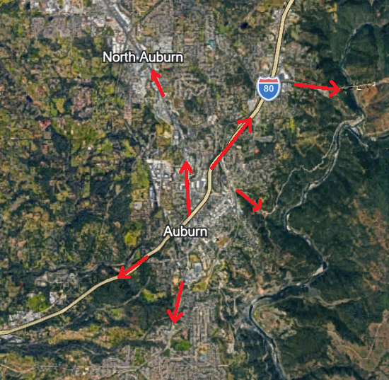
Emergency exit planning refers to the creation of clear and accessible routes that can be used to evacuate a building in case of an emergency. Egress planning extends the concept to the entire community, focusing on the ability of all individuals, including those with assistance needs or disabilities, to evacuate safely and efficiently during a disaster. Proper planning for household and community evacuation during a wildfire involves ensuring that exit routes are clear, signage is visible, and safety procedures are well-communicated and understood by everyone. A successful evacuation is one where everyone at risk safely and efficiently vacates the hazardous area without injury or loss of life.
How does egress planning for wildfires differ from planning for other disasters?
When a wildfire is approaching a community and triggers evacuation warnings, conditions on the ground are often different - and more chaotic - than they would be in day-to-day life. Smoke from the oncoming fire can darken the sky to nighttime-like conditions and make it harder to see or drive. Embers can travel miles ahead of the flaming front and start spot fires close to the area being evacuated. Conditions change rapidly as the fire grows, winds shift, cars clog roads, and emergency responders need to access the area. Evacuating livestock or large animals compounds the challenge since animals may be frightened and unresponsive; hooking up a trailer in smokey conditions is time-consuming; and trailers in the flow of traffic make for a more complex evacuation. Vehicle accidents become more likely and trees or powerlines may blow down in strong winds, potentially blocking evacuation routes. An approaching fire can also make it so that residents can only evacuate in one direction (away from the fire), cutting off some roundabout egress options.
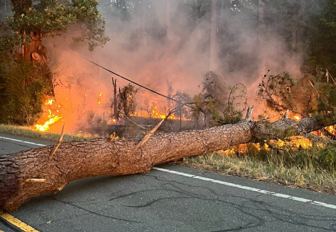
Photo from Eno Fire Department.
Communities that are most frequently threatened or impacted by fires, such as those in the wildland urban interface, are often relatively rural or isolated. They may have fewer roads into and out of the community because of landscape constraints (e.g. houses in a steep river valley where the terrain only allows for roads that parallel the river) or because they have less infrastructure overall. There is a much higher probability of something going wrong during evacuation for communities with only one road in and out. Proactive evacuation planning ahead of time by experts, community leaders, and residents is therefore critical.
Why is it important?
If an evacuation does not happen quickly and go smoothly, flame, ember, and smoke exposures (burnover conditions) can overtake evacuating residents or cut off egress routes. These burnovers during egress can result in injuries or fatalities. The 153,000-acre 2018 Camp Fire destroyed more than 18,000 structures and caused 85 fatalities; most of the damage happened and most lives were lost within the first four hours of this extremely fast-moving fire as the rapid fire spread affected evacuation routes, gridlocked roads, blocked-off exits, and eventually overtook evacuating residents (2018 Camp Fire After Action Report).
Planning for multiple, passable, well-marked exit routes and backup evacuation options before a fire happens can save lives. Residents who know the egress plan for their community are empowered to respond to an evacuation notice quickly and safely.
How to Improve Egress Routes
Building familiarity, forming a personalized plan
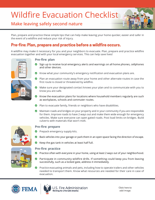
Click to view a comprehensive guidance document from FEMA for preparing for evacuation.
Improving your community’s egress routes starts with pre-fire planning, preparation and practice before a wildfire occurs. This includes knowing the current community evacuation plan and building your own evacuation procedures around it.
Become familiar with what your community’s emergency notification and evacuation plans are. Identify several pre-planned routes away from your home and out of your community in different directions in case the first route is closed or threatened. In most cases, you will be evacuating away from a fire, storm, or disaster that will be blocking travel in specific directions, so have alternatives.
Know the evacuation plans for locations where household members regularly are, such as workplaces, schools and commuter routes. Decide who will pick up children and pets. Ask the staff at your children’s schools and other organized activities what their evacuation and parent reunification plans are and include them in your personal evacuation plan.
Many cities and towns now include pet shelters in their emergency management plans. At most pet shelters, you will need to provide your pet’s own supplies, such as food, cages, bedding, toys, and medications.
Work with local leaders to regularly organize and hold community wildfire evacuation exercises. These community drills help educate residents on evacuation procedures and egress routes and prepare them for what an evacuation will feel like. They can also help local emergency responders understand how long it will actually take for residents to evacuate (Drilling for Disaster Preparedness, 2026).
Figure out how you will receive warnings on all home phones, cellphones, and other devices. Sign up local emergency notifications through your city or county’s emergency management office. In Albuquerque, for example, the Office of Emergency Management coordinates flexible evacuation plans depending on the situation, rather than having fixed routes for every hazard.
Maintain roads and bridges on your property (and in your community, if you are responsible for them).
Make sure everyone who needs to can open gated roads.
Build or replace culverts with materials that won’t melt. You can also prepare for post-fire impacts to roads by replacing or upgrading culverts to be able to accommodate post-fire flooding and debris flows (Post-Fire Treatments - A Primer for New Mexico Communities, page 29).
Improve roads to make them wide enough for emergency vehicles. Learn more about how to determine whether your property is accessible and defensible.
Locate several places you could go if you are evacuated, including homes of relatives or trusted friends in other communities. This will serve as a final destination for you and your family to go until it is safe to return home. You can use the FEMA app to find open shelters during an active disaster.
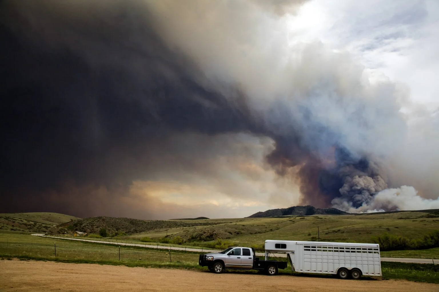
Know where livestock can be taken during an evacuation and when they should be evacuated. Fairgrounds, rodeo grounds, and equestrian centers are common sheltering locations for large animals. Evacuate your livestock early, as large animals require significantly more time to load and transport. Do not wait until a mandatory evacuation is ordered.
When voluntary evacuations are called, begin loading and transporting your animals immediately. Livestock can sense smoke and stress, which often causes them to resist loading.
If a fire is moving quickly and you are unable to evacuate your livestock, prioritize your own life and safety. Turn your animals out into a large, heavily grazed or irrigated pasture. Remove all halters and do not lock them in wooden barns, which are highly flammable.
Improving egress and exit options
Improving existing roads, identifying additional existing evacuation routes, and building new evacuation routes are all steps that communities can take to stay safer. In addition to identifying egress options, residents and leaders can take advantage of free tools for community evacuation planning. ESCAPE is one such tool. This research-based method is developed from case studies of destructive wildfires in the Wildland-Urban Interface (WUI). It offers actionable insights and planning tools to enhance community evacuation strategies.
Improving existing roads
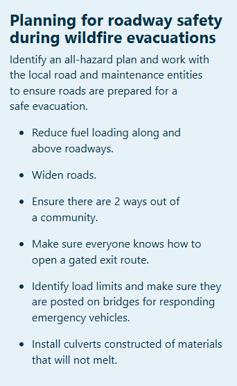
Residents can work with their neighbors and community leaders to improve the condition of their existing roads. Widen narrow roads and remove low-hanging tree branches or other obstructions to ensure that emergency vehicles can access the area. Ensure that roads are safe for evacuation by reducing the potential for open flames along key egress routes and travel arteries. Hardening of evacuation routes can be accomplished by reducing the amount of flammable material along these roadways (also called fuels management) so that evacuating vehicles will not be exposed to direct flames, maintaining tenability of the egress routes and allow evacuees to remain in their vehicles and exit to safety.
Create horizontal clearance by removing (cutting) hazardous vegetation, brush, and trees at least 10 feet out from the edge of the road.
Prune tree limbs up 3-4 feet off the ground along the roadside to prevent ground fires from climbing into the tree crowns (reduce ladder fuels).
Mow tall grasses, especially invasive non-natives, growing along roadsides.
Access routes should be an all-weather packed surface capable of supporting the weight of fire apparatus (up to 75,000lbs). Vegetation should be removed or pruned to provide at least 13.5 feet of vertical clearance above road surface to allow for fire response vehicle passage.
Building new roads
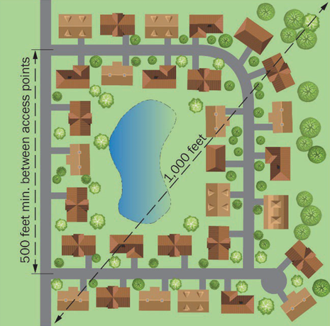
Functional road redundancy refers to the design of a road network so that if one route is blocked or damaged, alternative routes remain available to maintain or restore transportation and evacuation capabilities during disasters. Access/egress routes should also be spaced sufficiently so that both routes are not blocked during a wildfire emergency event.
Figure is from Best Practices for Wildfire-Resilient Subdivision Planning, page 21.
Improving your functional road redundancy saves lives. A recent study out of UC Santa Barbara found that one of the strongest predictors of wildfire fatalities may be the number of roads out of a community, with fatalities dropping sharply as communities gain more outward road access. “There are 17 million Americans living in communities [with poor road infrastructure] that are not designed survive a fast-moving wildfire… If you know you’re in an egress-limited community, you should have conversations with your family, your neighbors, your community, [and your city planners] about what the evacuation plan is.” This interactive map shows communities across the nation with a combination of high fire risk and six or fewer functional exits (Six Exits to Safety, 2026).
“Current building codes and standards are primarily focused on mitigating interior building fires for single parcels or buildings. However, access and egress requirements to safely manage people (e.g., number, separation of, and capacity of exits) are aimed at getting people out of buildings. There currently is not an equivalent fire safety code, standard, or consensus document that requires provisions for people management during wildfire events at neighborhood-, community- or regional-scales. This means that most existing and new developments may not have a sufficient number, arrangement, or capacity of egress routes to evacuate all residents to a relative place of safety during a major wildfire incident or allow for sufficient access for first responders” (Best Practices for Wildfire Resilient Subdivision Planning, 2025).
Identifying additional evacuation routes
If constructing additional exit routes is not a feasible solution for your community, identify nearby unimproved roads which can serve as tertiary evacuation routes. For WUI communities, there may be roads on nearby public land (such as Forest Service roads) that lead away from the area and can serve as critical secondary evacuation routes or safety corridors. though they pose specific challenges. Because these dirt or gravel roads can be narrow and rocky, local planners and residents should use official tools to map their egress, such as the Wildfire Risk to Communities Map and local USDA Motor Vehicle Use Maps.
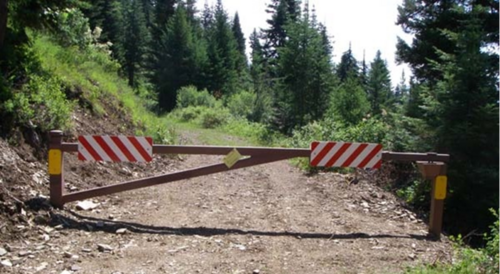
A gated entrance to a Forest Service road. Photo from Wikipedia.
Work with the relevant entity (e.g. the US Forest Service Forest Supervisor) to identify specific roads as designated egress routes, improve the road condition by grading or rocking the surface, and perform road hardening by removing roadside vegetation to make them safer for evacuation. For roads which are usually closed to the public but have been identified as potential egress routes to be used in case of an evacuation, request that standard closure gates be replaced with breakaway gates, also called crash gates. These structures prevent unauthorized daily access but are designed to collapse safely upon heavy impact and may be bypassed during evacuation. Read about how these structures are being utilized in evacuation planning for the community of Placitas.
Road-building alone is not a complete solution – steep terrain, ecological constraints, and cost make new roads impractical in many places. Instead, consider these three complementary approaches:
expanding egress infrastructure where feasible,
improving early warning systems and evacuation behavior, and
investing in pre-planned shelter-in-place options like temporary refuge areas for when evacuation fails.
Building egress into development design
As new developments are proposed or planned, work alongside local fire departments and your Fire Chief to talk to your city council, city planners, and elected officials. Help them understand that evacuation route diversification is an essential safety consideration and multiple routes of egress must be included in development design from the beginning. Updates may be made to local building ordinances to ensure that multiple exit routes are required. Conversely, city councils should involve fire professionals and integrate fire-related concerns at an early stage in strategic planning processes.
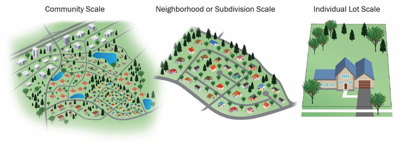
Schematic illustrating scale differences critical for holistic wildfire resiliency planning (adapted from UCANR 2020). Learn more: Best Practices for Wildfire-Resilient Subdivision Planning
The biggest takeaways
Road improvement and construction is an important piece of evacuation planning. However, much of the impetus for staying safe comes back to this core lesson: you are responsible for your own safety. Be prepared with your go bag, sign up for emergency notification alerts, have an evacuation plan and personalized procedures in place, and ensure that you have clear egress on your own property which allows for you to safely evacuate and for emergency response vehicles to access your home.
Have an evacuation plan in place
Have your go bag packed and ready at all times. Know where other items you will want to take with you, such as photo albums or medications, are located.
If you need assistance evacuating, have a plan for who will help you leave. This could be a family member, friend, neighbor, or a home health professional.
Know the exits from your community, including tertiary evacuation routes (such as Forest Service roads which are not utilized as a usual means of travel).
Evacuate early
Fires are moving faster and populations are growing, especially in previously rural areas. This means that when a wildfire approaches, more people are trying to evacuate in a shorter time period. Plan to evacuate early, especially if you are a member of a vulnerable population (those with mobility limitations, medical devices, young children, sensitive to smoke).
Individuals with assistance needs or who are part of a vulnerable population can register with their fire department ahead of time.
Regardless of the number of evacuation routes available in your community, being prepared with a go bag and leaving early can help reduce road congestion.
Evacuate according to the guidance of local emergency responders.
Official evacuation alerts on your mobile device or on the radio include specific instructions about what communities need to evacuate and where they should go.
Know how you are going to get in touch with your family or members of your household once you have evacuated.
Identify a common contact - this should be someone who lives in another community and who everyone in the family will independently get ahold of to check in.
Determine multiple agreed-upon meeting places. Know where you will gather depending on the direction from which the fire is approaching.
Additional Resources
Upcoming webinars
August 5, 11am-12pm: Better Together: The Power of Relationships in Fire Management
The solutions to obstacles in improving fire management are nuanced and local, but united by a common theme – the need to work together. This webinar will cover case studies from around the Fire Learning Network that show how focusing first on building trust and relationships leads to authentic, sustained partnerships that are capable of making fundamental change for the better in how we live and work with fire.

August 6, 12-1pm: 2025 New Mexico Forest Health Conditions - A View from Above
Each year the New Mexico Forestry Division partners with the United State Forest Service - Aerial Survey Program to conduct aerial detection surveys (ADS) of approximately 14 million acres of forests and woodlands in New Mexico. Through ADS, surveyors can observe and digitally map forest health conditions. Join FACNM and Forestry Division for this upcoming webinar to learn more about the conditions observed in 2025.